Counties in the Polish Lands in the Nineteenth and Early Twentieth Centuries
Authors: Joanna Górska-Szymczak, Stanisław Górski
The successive partitions of the Polish–Lithuanian Commonwealth carried out by Russia, Prussia, and Austria from 1772 onward led to the gradual dismantling of the constitutional order previously in force in the annexed territories. It should be emphasised that all three partitioning powers possessed political systems characterised by a high degree of centralisation 1 . Operating within so-called absolutist systems 2 , the new rulers introduced administrative arrangements fundamentally incompatible with the freedom-based constitutional model of the former Commonwealth. Moreover, the overt drive to exert strict control over the Polish population, often accompanied by policies of Germanisation or Russification, motivated by fears of restorationist aspirations, resulted in sustained and systematic pressure. One of the principal instruments of this pressure consisted precisely in the new administrative structures and institutions imposed by the partitioning powers in the annexed territories.
It hardly needs to be added that, in practice, the constitutional frameworks of these states offered no meaningful forms of social representation, let alone genuine participation in governance. Their highly centralised and powerful state administrations, operating through local agencies, relentlessly implemented imperial policy. From the standpoint of the present analysis, however, these issues lie outside the core subject of inquiry and will therefore not be pursued further here.
Genuine changes in a proto-constitutional direction 3 in these states (Austria and Prussia) began only in the early decades of the second half of the nineteenth century. Even then, it was only in practice, at the turn of the nineteenth and that one may speak of the emergence of rudimentary forms of democratic political life 4 . In Russia, by contrast, only weak and highly limited attempts to introduce para-democratic solutions can be identified, and these occurred solely in the final decade preceding the outbreak of the First World War in 1914 5 .
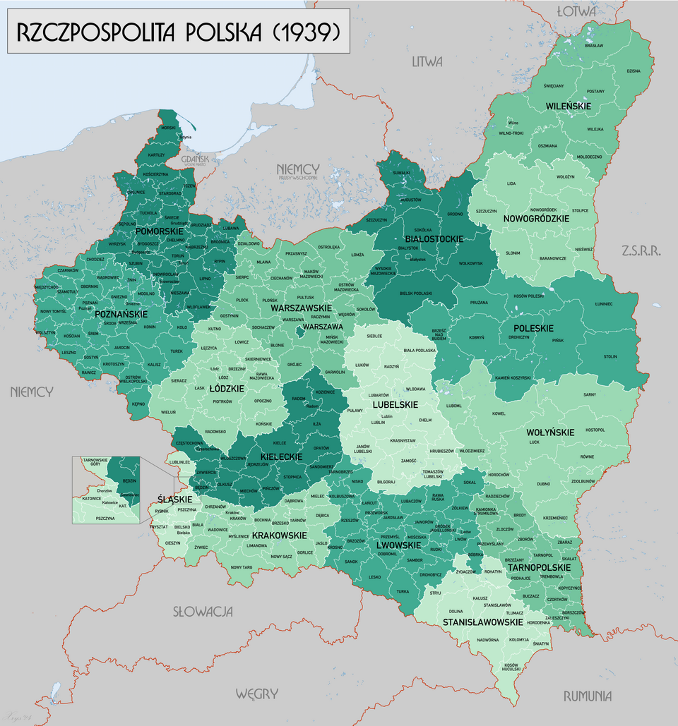
From the perspective of the present study, however, the processes initiated in the occupied Polish lands at the turn of the nineteenth and twentieth centuries are of particular importance. This is so primarily because the county-level territorial structures introduced by the partitioning powers were, as a rule, retained in the reborn Polish state after 1918. Above all, the analysis will seek to determine whether political preferences revealed in electoral processes at the county level within the partitioning states bore any relationship to later political sympathies in the Second Polish Republic.
These considerations must therefore begin with an examination of the development of county-level territorial structures in the Polish lands at the turn of the nineteenth and twentieth centuries. The focus will be on those counties that later lay within the borders of the Second Polish Republic and, subsequently, within the post-1945 Polish state.
In the Austrian partition, constitutional reforms implemented in the 1860s led to the establishment, within the Austrian half of the Habsburg Empire, of the autonomous Crown Land of Galicia 6 . As part of this reform, the earlier division of crown lands into districts (obwody), headed by district governors, and counties (cyrkuły), headed by county governors, was replaced by a uniform system of new territorial units known as counties (Bezirk). It should be emphasised that Galicia was one of only four crown lands in Austria in which, following empire-wide administrative reforms, county-level self-government was introduced 7 .
At this level, a distinctive relationship developed between the organs of state administration and local self-government. On the one hand stood the county governors (starostowie powiatowi), who were subordinate, through the provincial governor (namiestnik), to the central authorities in Vienna. On the other hand were the self-governing bodies elected by the local population: the county council and the county executive board (wydział powiatowy), the latter elected by the council itself. The county executive board served as the executive organ of self-government. It was headed by a president (the county marshal) and composed of six members In practice, the board operated in close cooperation with the county governor, jointly carrying out the administrative tasks assigned to the county level by statute. The county council was initially elected under a curial electoral system, with curiae corresponding to those used in elections to the Provincial Diet. Elections were held every six years. Over time, however, this system was replaced by universal and equal suffrage at the county level.
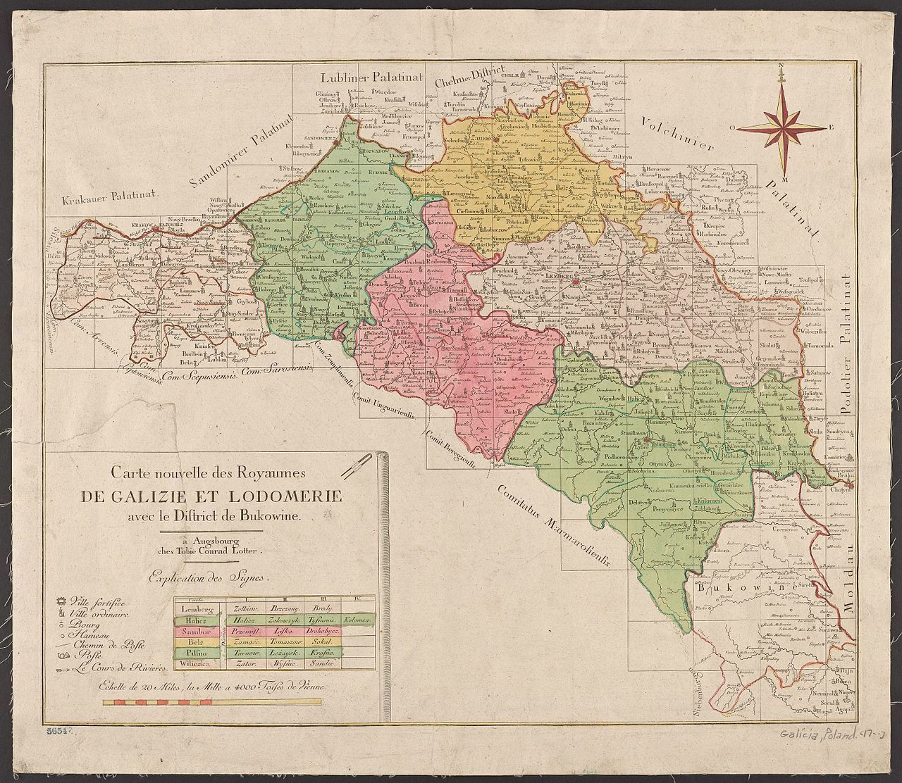
Figure 1. Map of the Kingdom of Galicia and Lodomeria, showing the original division into six districts (cyrkuły). Source: Wikimedia Commons, The Kingdom of Galicia and Lodomeria, https://pl.wikipedia.org/ wiki/Kr%C3%B3lestwo_Galicji_i_ Lodomerii [accessed on: 14.12.2025].
During the period of state reconstruction, the Polish Liquidation Committee 8 issued, on 23 November 1918, a regulation democratising the electoral system for the deliberative bodies of municipal and county self-government 9 . At the same time (for obvious reasons), the institution of provincial self-government was abolished.
Following the administrative reforms of the 1860s, the crown land of Galicia comprised seventy-four counties (powiaty). Subsequent changes to the territorial administrative system, introduced in 1900, increased their number to eighty-two.
Of the Galician counties, thirty-two ultimately remained within the borders of Poland after 1945. These were: Kraków, Chrzanów, Wieliczka, Bochnia, Brzesko, Wadowice, Biała, Żywiec, Myślenice, Nowy Sącz, Nowy Targ, Limanowa, Grybów, Gorlice, Tarnów, Dąbrowa, Ropczyce, Mielec, Pilzno, Jasło, Rzeszów, Kolbuszowa, Tarnobrzeg, Nisko, Łańcut, Sanok, Lesko, Bircza, Brzozów, Krosno, Przemyśl, and Jarosław.
In the Prussian partition, self-government, similarly to the Austrian model, was organised on three levels: provincial, county, and municipal (both rural and urban).
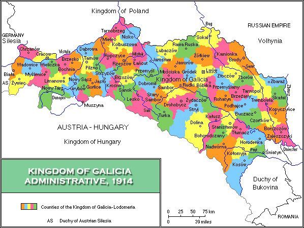
Figure 2. Map of counties in Galicia at the end of the nineteenth century (prior to the administrative changes introduced in the early twentieth century). Source: Wikimedia Commons, https://pl.wikipedia. org/wiki/Lista_powiat%C3%B3w_ Kr%C3%B3lestwa_Galicji_i_ Lodomerii_w_latach_1850%E2%80%931918 [accessed on: 14.12.2025].
The legal position of county self-government was regulated by the Act of 13 December 1872 on the county system 10 . Under this statute, the deliberative body at the county level became the county assembly (sejmik powiatowy). Its members were elected through a relatively complex electoral procedure combining direct and indirect elements and subject to high property-based suffrage qualifications. Initially, county assemblies possessed only limited competences (the so-called “own powers”), but these were gradually expanded.
Executive authority was exercised by the county board (wydział powiatowy), which was elected by the assembly. Both the county assembly and the county board were headed by the county governor (starosta powiatowy), appointed by the king. In this capacity, the starosta combined the functions of state administration with those of local self-government.
The framework of county self-government was further refined by two statutes adopted a decade later: the Act of 30 July 1883 on general state administration 11 and the Act of 1 August 1883 on the jurisdiction of administrative and administrative-judicial authorities 12 .
The harmonisation of administrative structures across the German Empire was completed by 1900. Until the fall of the Second Reich, no significant changes were introduced either to the internal territorial division of the Kingdom of Prussia, which encompassed all Polish lands annexed by Prussia, or to that of the Empire as a whole.
As a consequence of these reforms, and following subsequent territorial adjustments, the following counties from the former Prussian partition were incorporated into the Second Polish Republic.
- Within the Pomeranian Voivodeship were the counties of: Puck (Maritime), Kartuzy, Kościerzyna, Tczew, Starogard, Chojnice, Tuchola, Świecie, Grudziądz, Lubawa, Brodnica, Chełmno, Wąbrzeźno, Toruń, and Sępólno, together with the urban (municipal) counties of Toruń and Grudziądz.
- Within the Poznań Voivodeship were the counties of: Wyrzysk, Wągrowiec, Gniezno, Witkowo, Mogilno, Strzelno, Żnin, Inowrocław, Szubin, Bydgoszcz, Leszno, Śmigiel, Grodzisk, Nowy Tomyśl, Szamotuły, Oborniki, Poznań, Środa, Września, Śrem, Jarocin, Pleszew, Gostyń, Rawicz, Kościan, Krotoszyn, Ostrów, Kępno, Odolanów, and Ostrzeszów, as well as the urban counties of Bydgoszcz and Poznań.
- Within the Silesian Voivodeship were the counties of: Rybnik, Pszczyna, Lubliniec, and Katowice, together with the urban counties of Katowice and Królewska Huta (later Chorzów).
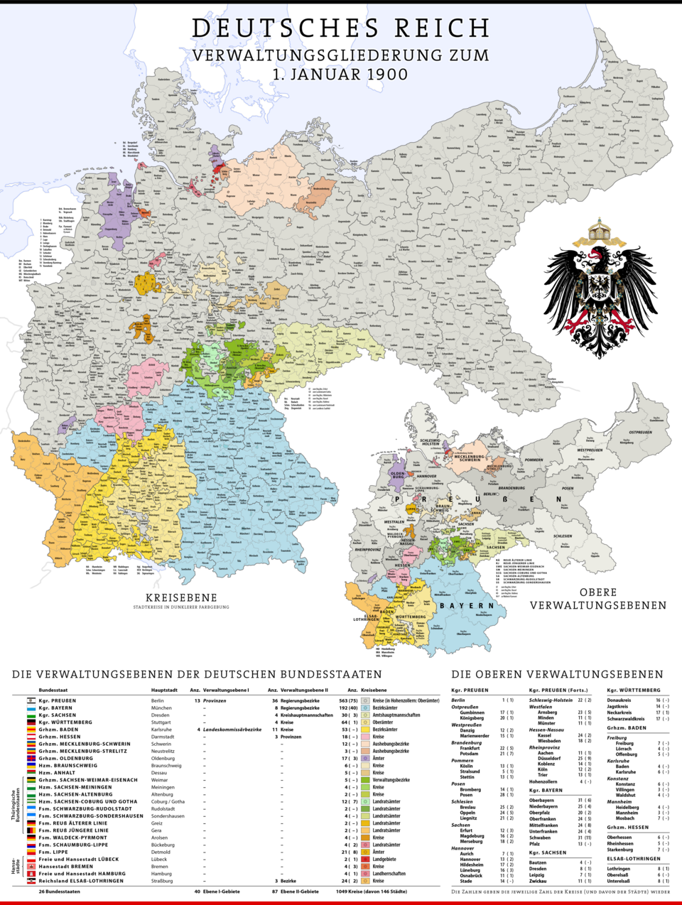
Figure 3. Administrative map of the German Empire in 1900, illustrating provincial and county divisions. Source: Wikimedia Commons, Administrative map, https:// en.wikipedia.org/wiki/German_Empire#/media/ File:Karte_Deutsches_Reich,_Verwaltungsgliede- rung_1900-01-01.png [accessed on: 14.12.2025].
By contrast, in the former Russian partition, self-government existed only at the level of rural municipalities. In addition, municipal self-government institutions operated in towns located in the territories of the so-called Eastern Borderlands – Volhynia, the Białystok region, Polesie, the Vilnius region, and Nowogródek.
The municipal system itself was highly complex. It was introduced in 1864 13 as part of the imperial authorities’ strategy to secure the loyalty of the peasantry during the January Uprising.
Four types of lower-level administrative units were established: peasant communes; mixed urban–rural communes; non-peasant communes (in privately owned villages); and manorial districts.
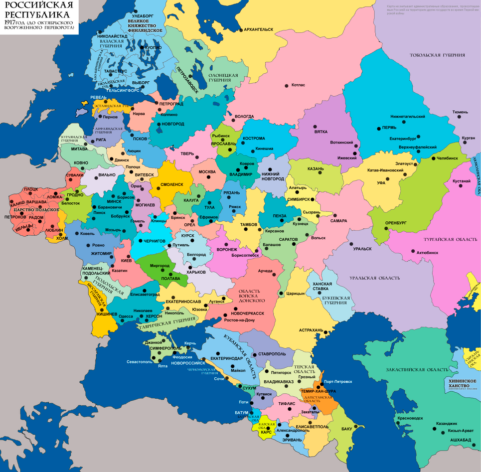
Figure 4. Administrative division into gubernias in the western part of the Russian Empire, c. 1900. Source: History of the administrative division of Russia, https://www.wikiwand.com/en/artic- les/History_of_the_administrative_di- vision_of_Russia [accessed on: 14.12.2025].
At the remaining administrative levels, Russian administrative models continued to operate, both at county and gubernial level. These arrangements were formally adapted to the specific conditions of the Kingdom of Poland in 1892 14 .
Further changes to the territorial organisation of the Kingdom of Poland occurred with notable frequency. On the one hand, they reflected broader transformations within the administrative structure of the Russian Empire; on the other, they constituted deliberate responses to successive Polish national uprisings. Each reorganization was intended to facilitate more effective control over territories regarded by the imperial authorities as politically unstable.
The original territory of the Kingdom largely corresponded to that of the former Duchy of Warsaw. The Duchy had been established on territories taken during the Third and Second Partitions by Prussia and the Third Partition by Austria 15 . In 1807, with the establishment of the Duchy, a French-style division into eight departments was introduced; these were further subdivided into counties. In the vast majority of cases, these counties constituted a continuation of territorial units that had existed prior to 1795.
Following the creation of the Kingdom of Poland in 1815, the territory was divided into eight voivodeships, subdivided into districts and then into counties. In 1837, the voivodeships were renamed gubernias, while the three-tier administrative structure was retained. A further reform in 1842 reversed earlier terminology: districts were again designated as counties, while the former counties became judicial districts. In 1845 the number of gubernias was reduced to five, only to be increased again to ten in 1867. Throughout these changes, the overall number of counties remained relatively stable. Additional reforms were introduced in 1893 and 1912.
By the beginning of the twentieth century, the final county network of what was then known as the Vistula Land had taken shape.
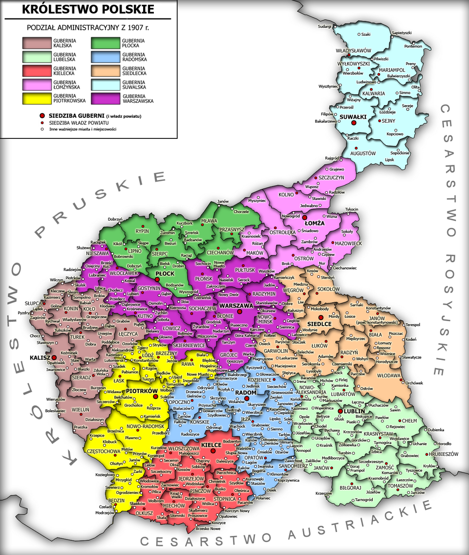
Figure 5. Administrative divisions of the Kingdom of Poland in 1907. Source: Wikimedia Commons, Administrative division of the Kingdom of Poland, https://pl.wikipedia.org/wiki/ Podzia%C5%82_administracyjny_Kr%C3%B3lestwa_Polskiego [accessed on: 14.12.2025].
As illustrated by the above map, the essentially final county network in the Kingdom of Poland on the eve of the First World War comprised:
- in the Kalisz Governorate: Kalisz, Koło, Konin, Łęczyca, Sieradz, Słupca, Turek, and Wieluń counties;
- in the Kielce Governorate: Jędrzejów, Miechów, Kielce, Olkusz, Pińczów, Stopnica, and Włoszczowa counties;
- in the Lublin Governorate: Janów, Krasnystaw, Lubartów, Lublin, Łuków, Nowa Aleksandria (Puławy), Garwolin, Siedlce, Sokołów, and Radzyń counties;
- in the Łomża Governorate: Kolno, Łomża, Maków, Mazovia, Ostrołęka, Ostrów, Szczuczyn, and Węgrów counties;
- in the Piotrków Governorate: Będzin, Brzeziny, Częstochowa, Łask, Łódź, Noworadomsk (Radomsko), Piotrków, and Rawa counties;
- in the Płock Governorate: Ciechanów, Lipno, Mława, Płock, Przasnysz, Rypin, and Sierpc counties;
- in the Radom Governorate: Iłża, Końskie, Kozienice, Opatów, Opoczno, Radom, and Sandomierz counties;
- in the Siedlce Governorate (later renamed the Chełm Governorate): Biała, Konstantynów, Włodawa, Tomaszów, Zamość, Biłgoraj, Chełm, and Hrubieszów counties;
- in the Suwałki Governorate: Augustów, Kalwaria, Mariampol, Sejny, Suwałki, Władysławów, and Wołkowysk counties;
- in the Warsaw Governorate: Błonie, Gostynin, Grójec, Kutno, Łowicz, Nieszawa, Nowy Mińsk, Płońsk, Pułtusk, Radzymin, Skierniewice, Sochaczew, Warsaw, and Włocławek counties.
The county network that emerged at the turn of the nineteenth and twentieth centuries across the Polish lands was transferred almost unchanged to the reborn Polish Republic after November 1918. This continuity resulted primarily from the fact that, in most cases, counties in their then territorial form represented a direct continuation of administrative units that had existed in the Polish–Lithuanian Commonwealth prior to 1795.
In the remaining so-called Eastern Lands (that is, territories formerly under Russian rule outside the Kingdom of Poland), Russian regulations governing rural communal self-government were initially retained. At the same time, the legal framework governing municipal and county self-government in central Poland was gradually extended to these areas. These regulations were introduced by regulations issued by the General Commissioner for the Eastern Lands 16 . This authority exercised civil administration over the territories in question until their affiliation with Poland was settled by treaty.
Ultimately, five voivodeships were established in these territories: Vilnius, Nowogródek, Białystok, Polesie, and Volhynia. Within them, county structures were created that broadly corresponded to the territorial divisions that had existed prior to the partitions.
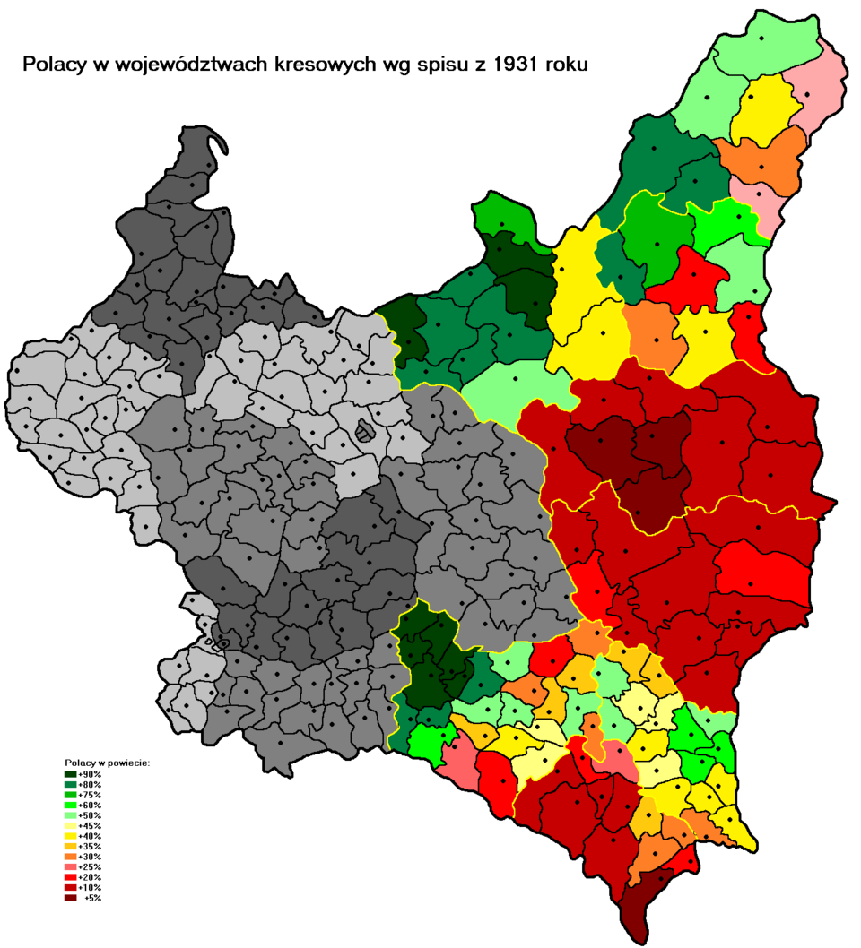
Figure 6. Map illustrating the share of the Polish population in the total population of the eastern borderland counties (Kresy) in 1931. The eastern voivodeships are indicated by yellow outlines (including those established in the eastern territories of Galicia—Lesser Poland), while county boundaries are marked in black. Source: Wikimedia Commons, The Polish–Lithuanian Commonwealth before 1660, https://pl.wikipedia.org/wiki/Kresy_ Wschodnie [accessed on: 14.12.2025].
1 In Austria, the process of intensifying the centralisation of the state apparatus, accompanied by the weakening of representative institutions and the restriction of territorial autonomy, began as early as the sixteenth century, initially in the Spanish Habsburg possessions and later across the remaining Habsburg lands. This tendency accelerated markedly after the Thirty Years’ War (1648). Similar processes occurred in Brandenburg, where a rapid intensification of centralisation can likewise be observed after 1648. By the eighteenth century, Prussian constitutional arrangements were characterised by an even higher degree of centralisation than those of the Habsburg Monarchy. The autocratic tradition of the Grand Duchy of Moscow was an inherent feature of its political system, shaped during the period of Mongol domination. Ivan the Terrible played a major role in consolidating this extremely centralised order. Its modern institutional form, however, was established in the early eighteenth century by Peter I, whose reforms defined the Russian Empire as an autocratic monarchy. For a broader discussion, see: G. Górski, Historia ustrojów państw, Warsaw 2001. For a fuller treatment of the administrative systems of these states, see: G. Górski, Historia administracji, 2nd ed., Toruń 2011.
2 There is little doubt that by the end of the eighteenth century all three partitioning powers of Poland represented some of the most advanced yet simultaneously most primitive and brutal absolutist systems in Europe. It is therefore striking that Polish historiography has often sought to minimise this reality, or even to suggest that these systems might have served as models for reform within the Polish–Lithuanian Commonwealth.
3 The substance of this concept is discussed in greater detail, with reference to an earlier period, in: J. Górska-Szymczak, Między…. The observations made there are, however, fully applicable to the nineteenth-century context considered here.
4 A concise discussion of this issue is provided in the analyses of the repeatedly cited work by G. Górski, Historia ustrojów państw.
5 Following Russia’s defeat in the Russo-Japanese War of 1904–1905 and the revolutionary upheavals of 1905–1907, limited attempts can be observed to democratise electoral law, to modify the constitutional position of the State Duma, and to expand the competences of territorial self-government.
6 Formally, in accordance with the imperial titulature of the Austrian emperor, the official designation of this crown land was the Kingdom of Galicia and Lodomeria with the Grand Duchy of Cracow and the Duchies of Oświęcim and Zator (German: Königreich Galizien und Lodomerien mit dem Grossherzogtum Krakau und den Herzogtümern Auschwitz und Zator).
7 Provincial Act of 12 August 1866 on county representation. Provincial Law Gazette No. 21. See also: J. Piwocki (ed.), Zbiór ustaw i rozporządzeń administracyjnych, Lviv 1909, vol. I, p. 464.
8 On 24 October 1918, representatives of Polish political parties operating in Galicia adopted a resolution calling for the immediate initiation of measures aimed at terminating the relationship of dependence on Austria. Four days later, the Polish Liquidation Committee was established and entrusted with the implementation of this objective. The political core of the Commission consisted of the Polish People's Party “Piast”, the National Democratic Party, and the Polish Social Democratic Party of Galicia and Silesia. The Commission was chaired by Wincenty Witos. For a more detailed discussion, see: M. Przeniosło, Polska Komisja Likwidacyjna 1918–1919 , Kielce 2010.
9 Regulation of the Polish Liquidation Committee of 23 November 1918 on the extension of electoral rights to municipal councils. Official Gazette of the Polish Liquidation Commission, no. 2.
10 County Ordinance for the Eastern Provinces of 13 December 1872. Prussian Law Gazette, p. 661; amended by the Act of 19 March 1881. Prussian Law Gazette, p. 233;
11 Act of 30 July 1883 on general state administration. Prussian Law Gazette, p. 155;
12 Act of 1 August 1883 on the jurisdiction of administrative and administrative-judicial authorities. Prussian Law Gazette, p. 237.
13 Act of 19 February / 2 March 1864 on the organisation of rural communes in the Kingdom of Poland. Digest of the Laws of the Russian Empire (1892), vol. II, arts. 194–313.
14 Gubernial and county administration in the Kingdom of Poland was regulated by a tsarist decree of 19/31 December 1866. Digest of the Laws of the Russian Empire (1892), vol. II, arts. 1–125
15 For a broader discussion of this issue, see: G. Górski, Akt 5 listopada w perspektywie historyczno prawnej, in: Historia Integra. Księga pamiątkowa ofiarowana S. Salmonowiczowi w 70-lecie urodzin, Toruń 2001, p. 357–368 and O znaczeniu Aktu 5 listopada. Na marginesie artykuły Dariusza Makiłły, Przegląd Sejmowy 2018, vol. 4, p. 7-17.
16
Regulation of the General Commissioner for the Eastern Lands of 27 June 1919 on the Provisional Municipal Act. Official Gazette of the Civil Administration of the Eastern Lands, no. 7, item 46; Regulation of the General Commissioner for the Eastern Lands of 16 August 1919 on the Organisation of Small Towns, Official Gazette of the Civil Administration of the Eastern Lands, no. 13, item 112; Regulation of the General Commissioner for the Eastern Lands of 7 November 1919 extending the Provisional Municipal Act to cities and towns with more than 2,000 inhabitants; Official Gazette of the Civil Administration of the Eastern Lands, no. 13, item 112.
Udostępnij