County-Level Administrative Units in Other European States
Authors: Grzegorz Górski, Witold Mazurek
As noted in the introductory remarks, the powiaty (or ziemie) that emerged in the Kingdom of Poland during the reign of Casimir the Great generally developed out of territorial units that had already existed in the pre-state period 1 . Across Europe, the formation of early administrative divisions followed broadly comparable trajectories; a decisive factor shaping their evolution, however, was the legacy of the Roman Empire.
The Roman Empire – Byzantium
In Western Europe, the earlier political collapse of the Empire, together with extensive migratory movements, meant that the territorial structures taking shape towards the end of the first millennium constituted a distinctive synthesis of Roman institutions and tribal, primarily Germanic, arrangements. In Central and
Eastern Europe, by contrast, the survival of the Roman Empire in its Byzantine form and its prolonged influence in the region meant that the interaction between Roman administrative models and tribal (mainly Slavic) structures likewise produced distinctive institutional solutions. Nevertheless, it was the administrative arrangements adopted and refined within Byzantium that exerted the most profound and lasting influence on the evolution of territorial structures across Europe as a whole. It is therefore useful to consider these developments in general terms, with particular attention to identifying territorial units that were functionally comparable to the Polish powiat.
A suitable point of departure is the administrative reorganisation of the Empire introduced at the turn of the third and fourth centuries CE by Emperor Diocletian. The new system of government he established – the Tetrarchy 2 – was accompanied by a division of the Empire into four major units, the Praetorian Prefectures of Gaul, Italy, Illyricum, and the East, each placed under the authority of one of the tetrarchs. These prefectures were initially subdivided into twelve dioceses: Britain, Gaul, the Seven Provinces, Spain, Africa, Italy, Pannonia, Moesia, Thrace, Asia, Pontus, and the East. Each diocese was headed by a Vicarius. The dioceses were further divided into provinces, whose total number rose to approximately one hundred, ranging from four to sixteen within a single diocese. At both the diocesan and provincial levels, civil and military administrations were institutionally separated – a measure intended to improve the efficiency of the Empire’s defensive system.
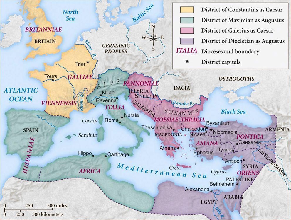
Figure 1. Administrative division of the Roman Empire introduced by Diocletian. Source: Wikimedia Commons, Administrative division of the Roman Empire, https://nl.wikipedia. org/wiki/Bestand:Roman_Tetrarchy_ map_-_RU.svg#/media/Bestand: R%C3%B6mische_Tetrarchie-es.svg [accessed on: 14.12.2025].
In subsequent centuries, within the eastern part of the Empire, which continued to exist without interruption, new territorial units emerged, most notably praetorian prefectures and themes. Alongside these, a range of extraordinary institutional arrangements appeared, including the quaestura exercitus, exarchates, kleisourai, archontates, tourmai, banda, and katepanika. These units were frequently created on an ad hoc basis in response to complex local conditions. n most cases, they took the form of combined civil–military structures designed to strengthen the Empire’s defensive capacity 3 . From the perspective most relevant to the present discussion, it is important to note that at lower administrative levels there existed territorial units known as pagi. These encompassed rural areas together with the villages (vici) and settlements located within them, often including fortified local centres (oppida) 4 .
At this point, one further concept that emerged within the still undivided Empire merits attention: the comes. Without entering into questions of etymology, the term came to denote a category of high-ranking officials within the imperial chancellery, a development that dates to approximately the reign of Emperor Diocletian 5 .
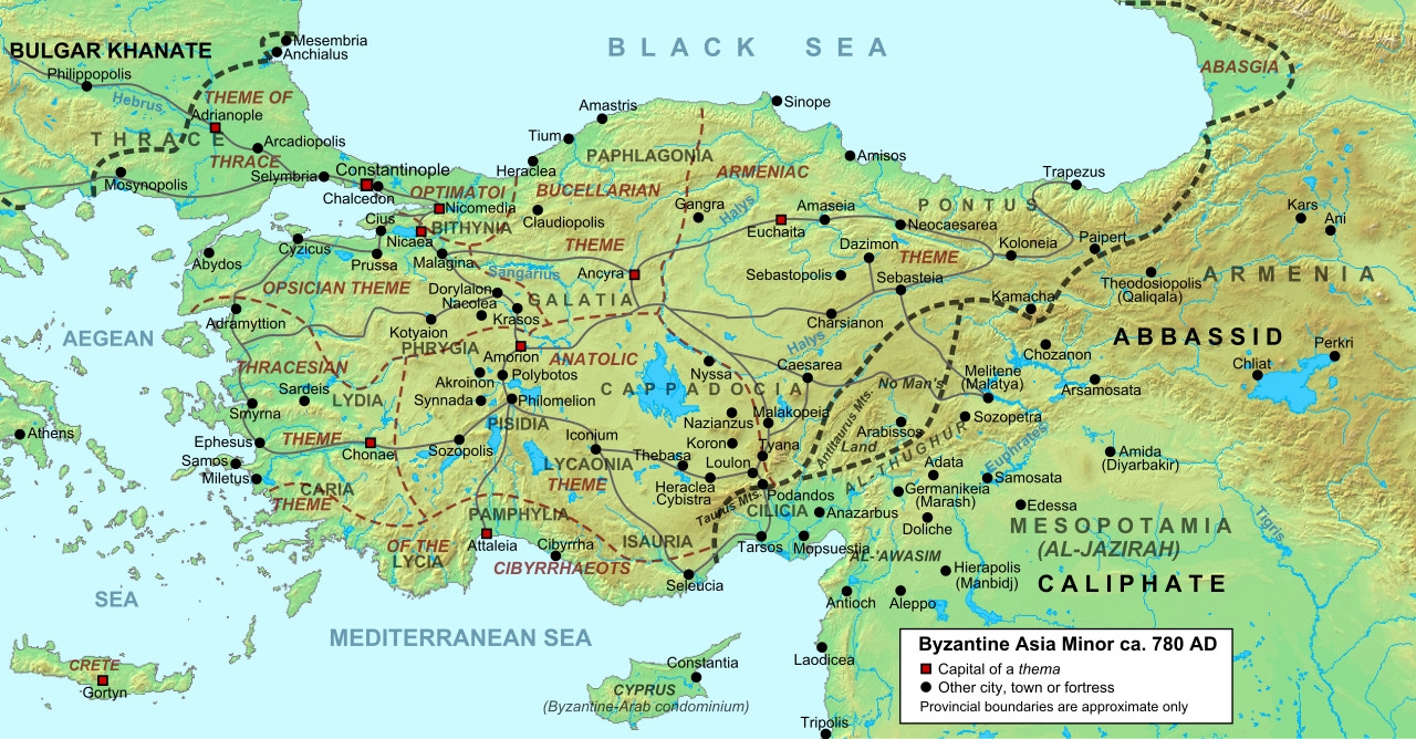
Figure 2. Part of the Roman (Byzantine) Empire at the end of the eighth century, showing the administrative division into themes. Source: Wikimedia
Commons, https://pl.wikipedia.org/wiki/Plik:Asia_Minor_ca_780_AD.svg [accessed on: 14.12.2025].
The most prominent official bearing this title was the deputy of the magister officiorum (the highest-ranking civil official of the imperial administration), known as the comes dispositionum. Other offices carrying the same designation included the comes domesticorum, comes privatae largitionis, comes rerum privatarum, comes sacrarum largitionum, comes auri, comes sacrae vestis, and, of particular significance, the comes rei militaris. Several of these offices survived into the period of the Ostrogothic and Visigothic kingdoms established in Italy and Spain. Within the administrative structures of these successor states, one encounters offices such as comes cubiculariorum, comes scanciorum, comes stabulorum, comes notariorum, and comes thesaurorum.
There can be little doubt that both the pagus as a territorial unit and the comes as a type of official also persisted in Gaul, where the Frankish Kingdom emerged from the fifth century onward. It is therefore unsurprising that these institutions reappeared in a modified form within the Carolingian Empire and spread from there across much of Europe.
Drawing on the pre-existing pagi, Charlemagne introduced a new territorial unit known as the comitatus (Old French comté). Each was headed by an official appointed by the ruler, initially designated as a comes. These districts were subdivided into centenae, which were administered by vicarii. The responsibilities of the comites included oversight of the vicarii, the administration of justice, the enforcement of capitularies, the levying of troops, the collection of tolls and dues, and the maintenance of roads and bridges. Although, in principle, they could be dismissed by the king, many of these offices gradually became hereditary 6 .
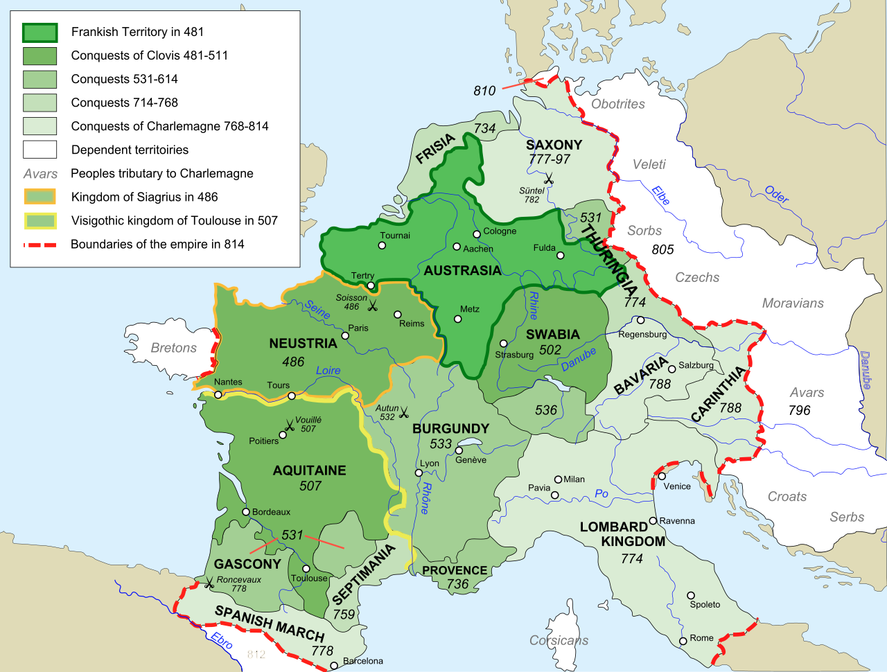
Figure 3. Map illustrating the territorial expansion of Charlemagne’s Empire. It shows how, on the basis of his conquests, the later major territorial units emerged, with pagi forming their lower-level subdivisions. Source: Wikimedia Commons, https://pl.wikipedia.org/wiki/Plik:Frankish_Empire_481_to_814-pl.svgf [accessed on: 14.12.2025].
The Carolingian model of territorial administration (much like the Carolingian conception of the state itself) came to function as a civilisational benchmark in Europe around the turn of the first millennium 7 . It should be emphasised that the reception of these institutional solutions was accompanied by a pronounced tendency towards the hereditary transmission of offices. This phenomenon was already visible within the Carolingian Empire itself. An attempt to counteract its consequences, above all, the erosion of the original purpose of these offices as instruments for transmitting the ruler’s will at the local level, was the parallel institution of the missi dominici. These royal envoys were tasked with supervising the implementation of royal law and authority within the districts. Comparable processes can be observed elsewhere; for example, the establishment of the office of starosta in the Kingdom of Poland was inspired by similar concerns, particularly in response to the growing autonomy of castellans.
The Kingdom of France
Within the Kingdom of France, territorial divisions long displayed a striking degree of diversity. This reflected deeply entrenched traditions whose roots extended back to the Celtic (Gallic) period. In his still-influential classical study, Fustel de Coulanges emphasised that Gallic legacies were preserved not only in the names of French provinces, but also in lower-level territorial units 8 . According to his analysis, subsequent Roman domination, followed by Germanic rule, later transformations of the French monarchy, and even the upheavals of the Revolution and the Napoleonic era, failed to bring about fundamental changes to these original divisions. The smallest territorial units of the Gallic period functioned as continuations of the Roman pagi and survived (largely unchanged) through the Frankish era, becoming the basic units of territorial administration in the Kingdom of France. Today, they find their modern counterpart in the arrondissement. 9
During the Roman period in Gaul, prior to its reorganisation under Diocletian, divisions into provinces developed, eventually numbering eleven. These were subdivided into lower units known as civitates, whose number had risen to 113 by the fifth century. These units corresponded closely to the pagi and later became components of the Carolingian administrative system. They functioned either within, or alongside, divisions into duchies, marches, or larger comtés.
As the Frankish realm fragmented between the ninth and twelfth centuries, the institutional structures of the Catholic Church (dioceses, parishes, and abbeys) assumed an increasingly prominent role. In the context of the growing weakness of secular administration, ecclesiastical institutions often took on functions normally associated with the state.
This weakness was especially evident in the administration of justice (where officials were appointed to adjudicate in the king’s name), fiscal management, and, over time, military organisation. In response, parallel administrative offices were created whose territorial scope did not correspond to existing divisions.
In the judicial sphere, the principal criteria shaping these new units were language and legal custom. Given the extraordinary diversity in both respects, new territorial jurisdictions emerged in the form of bailliages and sénéchaussées, headed respectively by baillis and sénéchaux. At the apex of this judicial system stood more than a dozen parlements, which functioned as supreme courts for territorially defined legal and linguistic regions.
For fiscal purposes, généralités were established. Their territorial extent was fluid and lacked permanence. In addition, gouvernements généraux were created as military districts forming the basis of army organisation. Ultimately, around forty such units emerged, nearly all of which have counterparts in territorial divisions that persist to this day.
Figure 4. Map illustrating the division of the Kingdom of France into general governorships (shown in different colours); red lines indicate the boundaries of the present-day departments. Source: Wikimedia Commons, https://commons.wikimedia.org/ wiki/File:1789_%2B_2022_France,_ noms_des_r%C3%A9gions.png [accessed on: 14.12.2025].
The advance of absolutism in France did not favour the survival of county-type structures. This tendency was reinforced by the centralising and bureaucratic reforms of the revolutionary and Napoleonic periods, which definitively consolidated this model of territorial administration 10 .
The Kingdom of England
Most counties in the Kingdom of England were established between the sixth and eleventh centuries 11 . They were territorial units created primarily to facilitate the administration of justice and the organisation of military obligations within defined areas. Each county was headed by a sheriff, who was usually appointed by the monarch, although in certain cases the appointment was made by powerful secular magnates, such as palatines or earls, or by ecclesiastical authorities, including bishops. The territorial configuration of these units represented a distinctive synthesis of residual Roman administrative structures (notably the pagi) and arrangements introduced by successive waves of Germanic settlers, which often reflected ethnic composition and linguistic boundaries. Following the Norman Conquest of 1066, the institution of the sheriff was extensively employed to strengthen royal authority. For a considerable period, these offices were held almost exclusively by members of the Norman elite, who were entrusted with wide-ranging fiscal and enforcement powers. In the thirteenth and fourteenth centuries, the emergence of Parliament led to counties acquiring the right to elect representatives to the developing House of Commons. Urban representatives formed the so-called parliamentary boroughs, while counties functioned as county constituencies. During the sixteenth and seventeenth centuries, the military role of sheriffs was gradually curtailed with the establishment of the office of lord lieutenant, who assumed responsibility for organising and commanding the county militia.
Both the number of counties and their boundaries, as well as the basic functions of administration at this level, remained largely unchanged until the mid-nineteenth century. More substantial alterations were associated with electoral reforms, which included the disfranchisement of certain boroughs and, under conditions of rapid demographic change, the adjustment of county boundaries or the creation of a limited number of new administrative units 12 . As a result, counties gradually evolved into standard units of local self-government. County councils were established as representative bodies of the local population, and sheriffs became subordinate to these councils rather than remaining directly accountable to central government. These changes were accompanied by a systematic expansion of the competences of local authorities.
Notably, despite these reforms, the number of counties increased only marginally, and since 1974 England has comprised forty-five counties 13 .
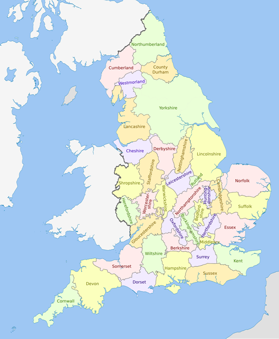
Figure 5. Map of English counties in the mid-nineteenth century. Source: Wikimedia Commons, https:// en.wikipedia.org/wiki/Historic_counties_of_England [accessed on: 14.12.2025].
The German Kingdom
In the eastern part of the Carolingian realm – Francia orientalis or Regnum Francorum orientalium – the formation of the German Kingdom began in the tenth century. In territories inhabited by Germanic peoples and previously incorporated by Charlemagne, so-called “older stem duchies” (ältere Stammesherzogtümer) initially emerged, notably Bavaria, Swabia, and Saxony. These were later joined by Franconia, Thuringia, and Lotharingia, often described as “younger stem duchies” (jüngere Stammesherzogtümer). Following the incorporation of Thuringia into Saxony, five principal stem duchies remained, which went on to play a leading role in the political life of the kingdom 14 . This interpretation, however, is no longer universally accepted 15 .
As recent Polish scholarship has emphasised 16 , irrespective of ongoing debates concerning the hierarchy and classification of territorial units in Francia orientalis, it may be assumed that five duchies – Swabia (Alemannia), Lotharingia, Bavaria, Saxony, and Franconia – held a dominant political position in the period under consideration. It was the rulers of these polities who played a decisive role in the early functioning of the realm.
As a rule, these territories preserved administrative systems derived from the Carolingian period. By the end of the first millennium, the emerging German Empire (Römisches Reich), in addition to the principal duchies, also encompassed Thuringia, Frisia, the Eastern March, the nascent Northern March, the Duchy of Bohemia, and substantial portions of Lotharingia 17 .
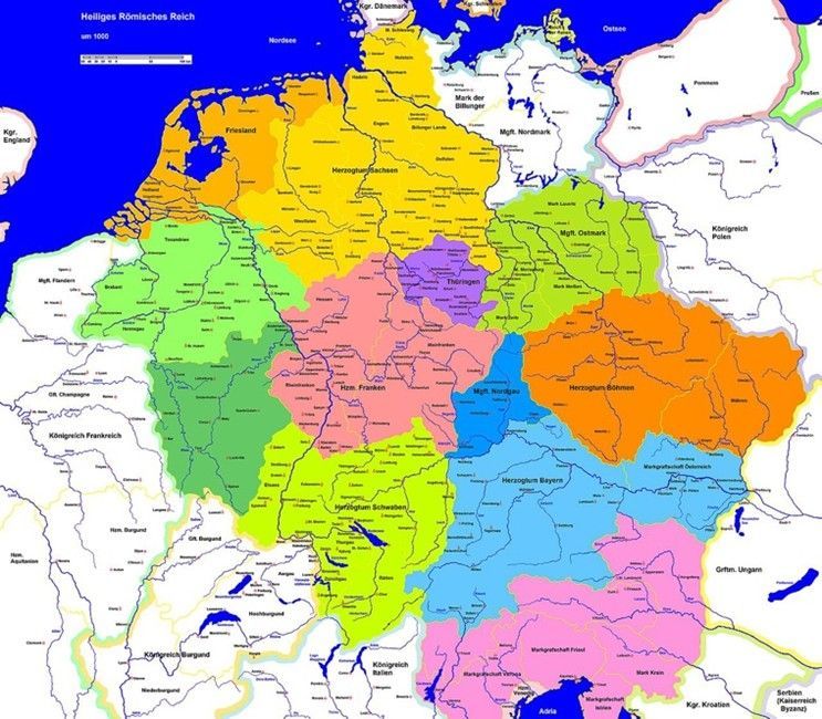
Figure 6. Map illustrating the territory of the German Empire at the turn of the tenth and eleventh centuries. Source: Wikimedia Commons, https://commons.wikimedia.org/wiki/File:Holy_Roman_Empire_11th_ century_map-en.svg [accessed on: 14.12.2025].
In the following two centuries, the Empire both expanded through the incorporation of additional polities and underwent increasing territorial fragmentation, resulting in the emergence of a growing number of highly diverse political entities. This process is illustrated in the map below.
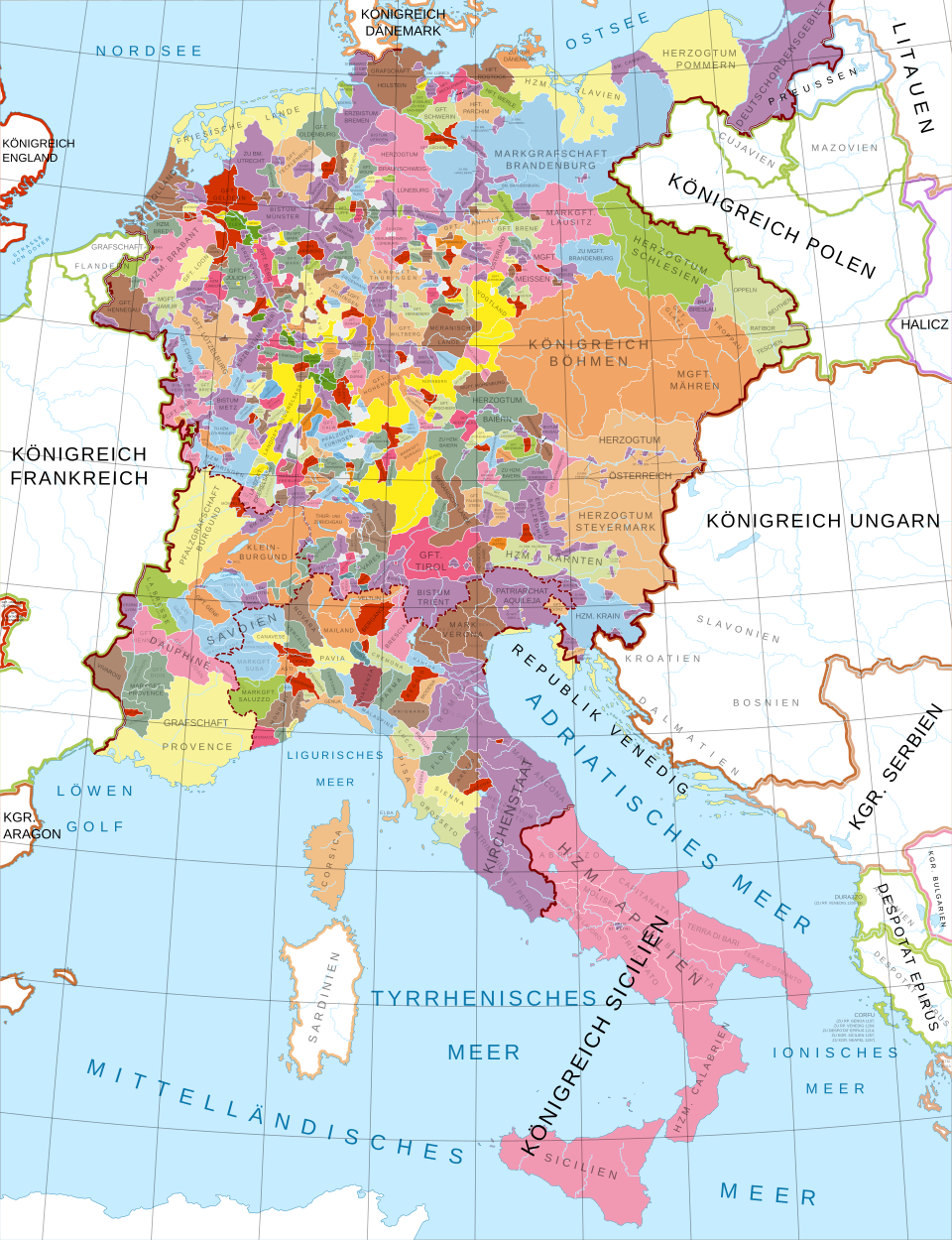
Figure 7. Central Europe during the period of the Hohenstaufen dynasty. Source: Wikimedia Commons, https:// commons.wikimedia.org/ wiki/File:Mitteleuropa_ zur_Zeit_der_Staufer.svg [accessed on: 14.12.2025].
By the fourteenth century, their number had increased still further.
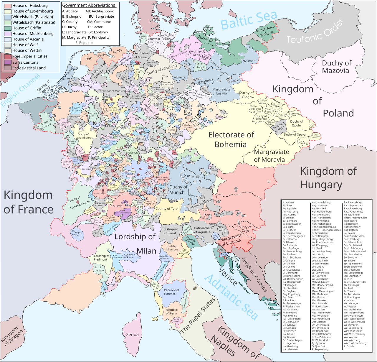
Figure 8. Map of territorial units within the Holy Roman Empire in 1356. Source: Wikimedia Commons, https://commons.wikimedia.org/wiki/File:The_Golden_Bull_of_1356.svg [accessed on: 14.12.2025].
Ultimately, the Reformation of the sixteenth century, together with the religious and political conflicts associated with it, followed by the Thirty Years’ War (1618–1648) and its conclusion in the Peace of Westphalia (1648), decisively shaped the territorial structure of the Holy Roman Empire. This period marked the point of greatest internal territorial fragmentation among the German states. In the decades that followed, processes of partial reintegration began to take place within the Empire.
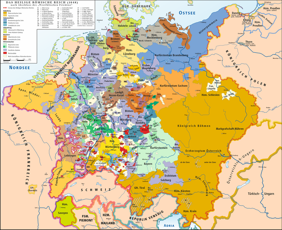
Figure 9. Map of the Holy Roman Empire after the Peace of Westphalia (1648). Source: Wikimedia Commons, https://pl.wikipedia.org/wiki/ Plik:HRR_1648.png [accessed on: 14.12.2025].
Among the territorial units of the Empire were:
- territories ruled by bishops as secular princes (Hochstifte),
- imperial abbeys governed by abbots (Reichsabteien),
- imperial circles established for purposes of collective defence (Reichskreis),
- imperial estates (Reichsstand),
- free imperial cities (freie Reichsstadt),
- states of the Empire (Reichsstände),
- numerous small polities – Kleinstaaterei. 18
- Electoral History of Poland (Sixteenth Century to the Early Twentieth
The Kingdom of Hungary
Close dynastic ties between the Piast dynasty and the Hungarian rulers of the Árpád house, and later the Angevins, facilitated the transfer of various constitutional and administrative solutions from the Kingdom of Hungary to the Kingdom of Poland. In this context, it is worth examining the formation of administrative divisions in the early stages of Hungarian statehood.
The territories occupied by the Magyars at the turn of the ninth and tenth centuries had previously formed part of Great Moravia. Within this polity, territorial units known as župa were widespread. These units were probably associated with larger tribal groupings among the Slavic population. Similar structures also existed in Croatia and Bulgaria. The term likewise appeared in southern Poland, where it survived in the Polish language, although it was eventually replaced by the term opole.
Following their arrival in the Carpathian Basin, the Magyars adopted this administrative unit, referring to it as vármegye, megye, or várispánság. Under the influence of contacts with the Carolingian Empire, and owing to the functional similarity between this unit and the Carolingian comitatus, the Latin term comitatus became widely used. This was especially the case in regions of the kingdom with a strong Slavic presence. Over time, the župa, or megye, came to be headed by officials known as župans or ispáns (várispáns).
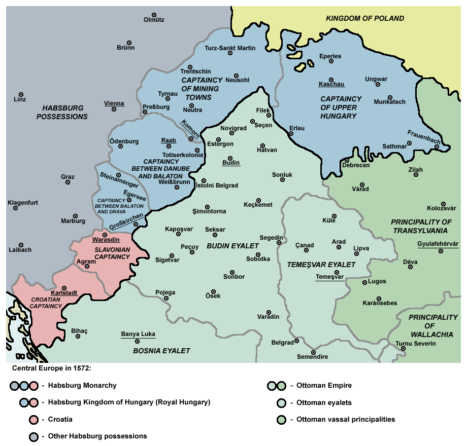
Figure 10. Map of the Kingdom of Hungary divided between Habsburg and Ottoman rule, with the counties of Transylvania and Wallachia, vassals of the Ottoman Sultan, also shown. Source: Wikimedia Commons, Territories of the Kingdom of Hungary, https://en.wikipedia. org/wiki/List_of_administrative_divisions_ of_the_Kingdom_of_Hungary#/media/ File:Central_europe_1572.png [accessed on: 27.07.2025].
By the eleventh and twelfth centuries, nearly fifty counties had been established within the Kingdom of Hungary. On the eve of the Ottoman conquest at the beginning of the sixteenth century, their number had risen to approximately seventy. Following the partition of Hungarian territories between the Habsburg Monarchy and the Ottoman Empire, these administrative units were largely retained by the occupying powers.
During the reconstruction of the Kingdom of Hungary as an equal component of the Austro-Hungarian Monarchy after 1866, the county structure was essentially preserved. Ultimately, the Kingdom comprised more than seventy counties, the overwhelming majority of which retained boundaries dating back to the medieval period.
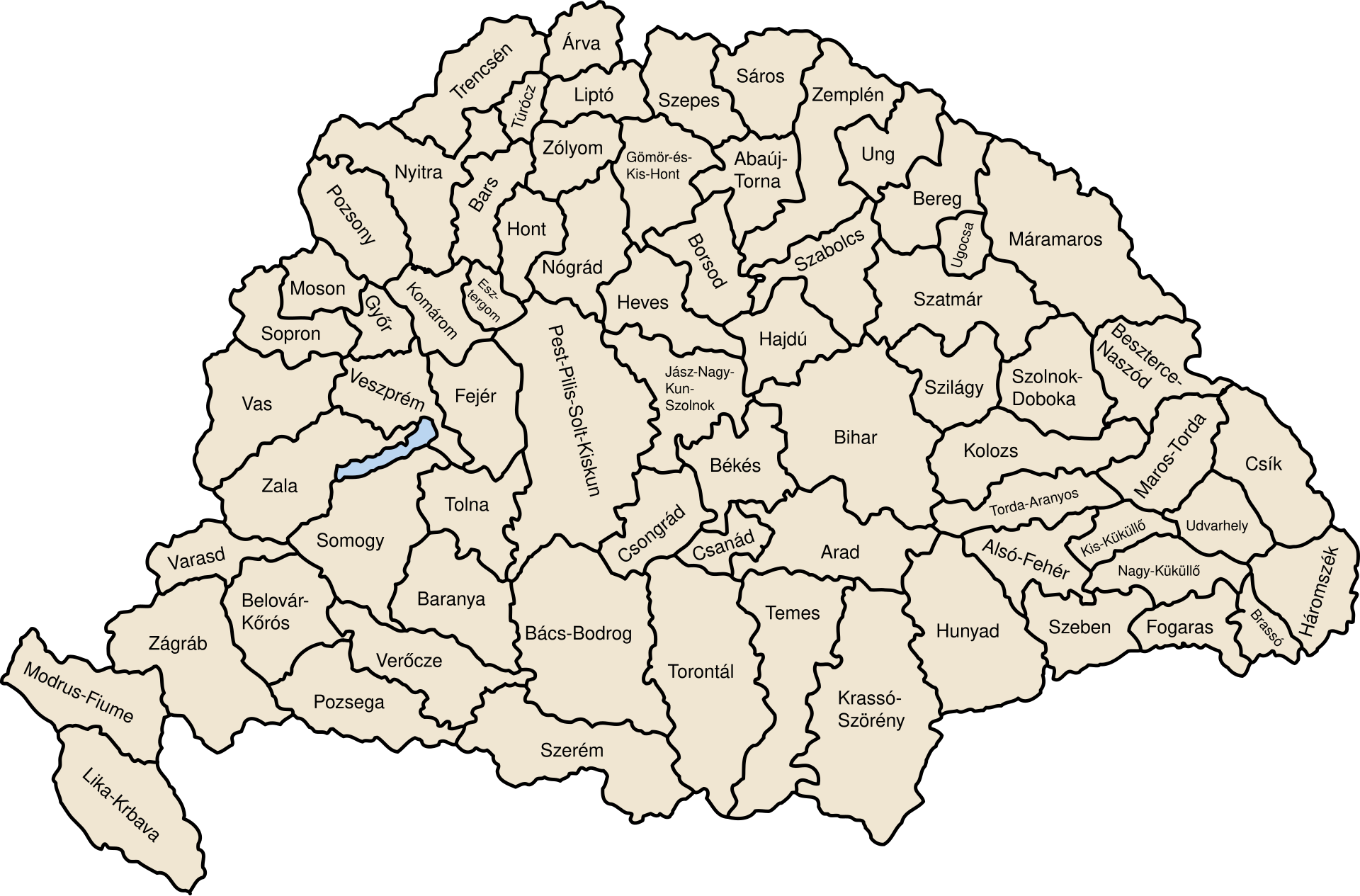
Figure 11. Counties of the Kingdom of Hungary after 1880. Source: Wikimedia Commons, Counties of the Kingdom of Hungary after 1880, https://en.wikipedia.org/wiki/List_of_administrative_divisions_of_the_Kingdom_of_Hungary#/me- dia/File:Kingdom_of_Hungary_counties.svg [accessed on: 28.07.2025].
It is also noteworthy that in the seventeenth century territorial units corresponding to counties appeared in both Denmark and Sweden.
In Denmark, they were introduced in 1660 under the name amter. Initially numbering twenty-four, their number was gradually reduced in subsequent centuries, and today sixteen such units remain.
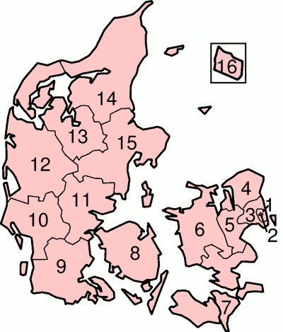
Figure 12. Present-day counties of Denmark. Source: Wikimedia Commons, Counties of Denmark, https://en.wikipedia.org/wiki/Counties_of_ Denmark#/media/File:DenmarkNumbered.png [accessed on: 28.07.2025].
It is also noteworthy that in the seventeenth century territorial units corresponding to counties appeared in both Denmark and Sweden.
In Denmark, they were introduced in 1660 under the name amter. Initially numbering twenty-four, their number was gradually reduced in subsequent centuries, and today sixteen such units remain.
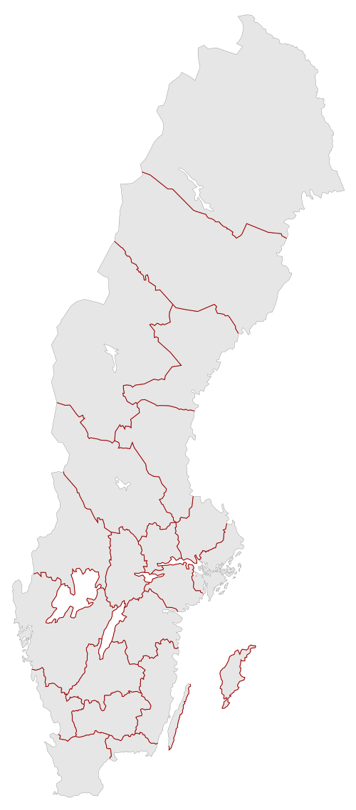
Figure 13. Counties of Sweden. Source: Wikimedia Commons, Counties of Sweden, https://en.wikipedia.org/wiki/County#/media/File:SWE-Map_L%C3%A4n.svg [accessed on: 28.07.2025].
In Sweden, a major administrative reform was enacted in 1634 by Chancellor Axel Oxenstierna through the so-called Instrument of Government. This reform established territorial units known as län. Numbering twenty-one, these units have survived to the present day with only minor modifications.
1 These conclusions are based on the findings presented by the previously cited J. Osiński,
2 Without entering into broader discussion, it should be recalled that Diocletian initially effected a distinctive division of the Empire into eastern and western parts, establishing a dual rule of two Augusti; at a later stage, one Caesar was appointed to each part. The resulting administrative system thus reflected a fourfold structure of imperial authority.
3 For a broader discussion of issues concerning the organisation of the state apparatus and the territorial structures of the Roman (Byzantine) Empire, see
G. Ostrogorsky, History of Byzantine State, Oxford 1956. See also: L. Maksimović, The Byzantine Provincial Administration under the Palaiologoi, Amsterdam 1988.
4 For a discussion of these units, see: O. Nicholson, The Oxford Dictionary of Late Antiquity. Oxford University Press 2018. s.v. pagus and pagarch; see also: S. Hornblower, A. Spawforth, E. Eidinow, The Oxford Classical Dictionary. Oxford University Press 2012, p. 1062
5 On the institution of the comes, see: H. Chisholm, Encyclopædia Britannica. vol. 7 (11th ed.). Cambridge University Press 1911, p. 312–314.
6 For a more detailed discussion of these solutions, see: M. Costambeys, The Carolingian World. Cambridge University Press 2011.
7 For a broader discussion of this issue, see: J. Górska-Szymczak, op. cit. and G. Górski, Historia administracji, Toruń 2002.
8 F. de Coulanges, Histoire des institutions politiques de l’ancienne France. Paris 1875, https://gallica.bnf.fr/ark:/12148/bpt6k61706f. texteImage [accessed on: 23.07.2025].
9 For a more detailed discussion, see: N. Verdier, La réforme des arrondissements de 1926, https://shs.hal.science/file/index/docid/467770/filename/ Verdier_La_reforme_des_arrondissements.pdf [accessed on: 23.07.2025].
10 For a broader discussion of these issues (though not without controversial interpretations) see:: M.L. Legay, Le fin de pouvoir provincial (4 aout 1789 – 21 septembre 1791), Annales historiques de la Révolution française 2003 (332), p. 25–53.
11 For a broader treatment of this subject, see: Aspects of Britain: Local Government. Her Majesty’s Stationery Office. 1996. See also the more comprehensive study: F. Youngs, Guide to the Local Administrative Units of England: Volume II. London 1991.
13 An insightful discussion of these processes can be found in: B. Keith-Lucas, Government of the County in England, The Western Political Quarterly, vol. 9, No. 1. (March 1956), p. 44–55.
14 Such view is proposed, inter alia, by P. J. Geary, Phantoms of Remembrance: Memory and Oblivion at the End of the First Millennium
Princeton University Press, 1994, p. 44 ff.
15 It should be noted that the thesis concerning the existence of “older” and “younger” stem duchies formed part of a strongly nationalist strand of German historiography, particularly in the period following unification in 1871 and later during the interwar years. An alternative interpretation is offered by H. Wolfram, The Shaping of the Early Medieval Principality as a Type of Non-royal Rulership, Viator 1971, vol. 2, p. 41 ff.
16 J. Górska-Szymczak, Między demokracją a absolutyzmem.
17 For a broader discussion, see: P. Collins, The Birth of the West: Rome, Germany, France, and the Creation of Europe in the Tenth Century, New York 2014.
18 For a broader discussion of the Empire’s complex territorial structure, see: The German Hereditary Territorial Rulers (History, territorial possesion, chronology, titles), http://grmrulers.altervista.org/ [accessed on: 16.08.2025].
Udostępnij