The Establishment and Development of the Network of Counties from the Fourteenth to the Eighteenth Century
Authors: Michał Z. Dankowski, Stanisław Górski
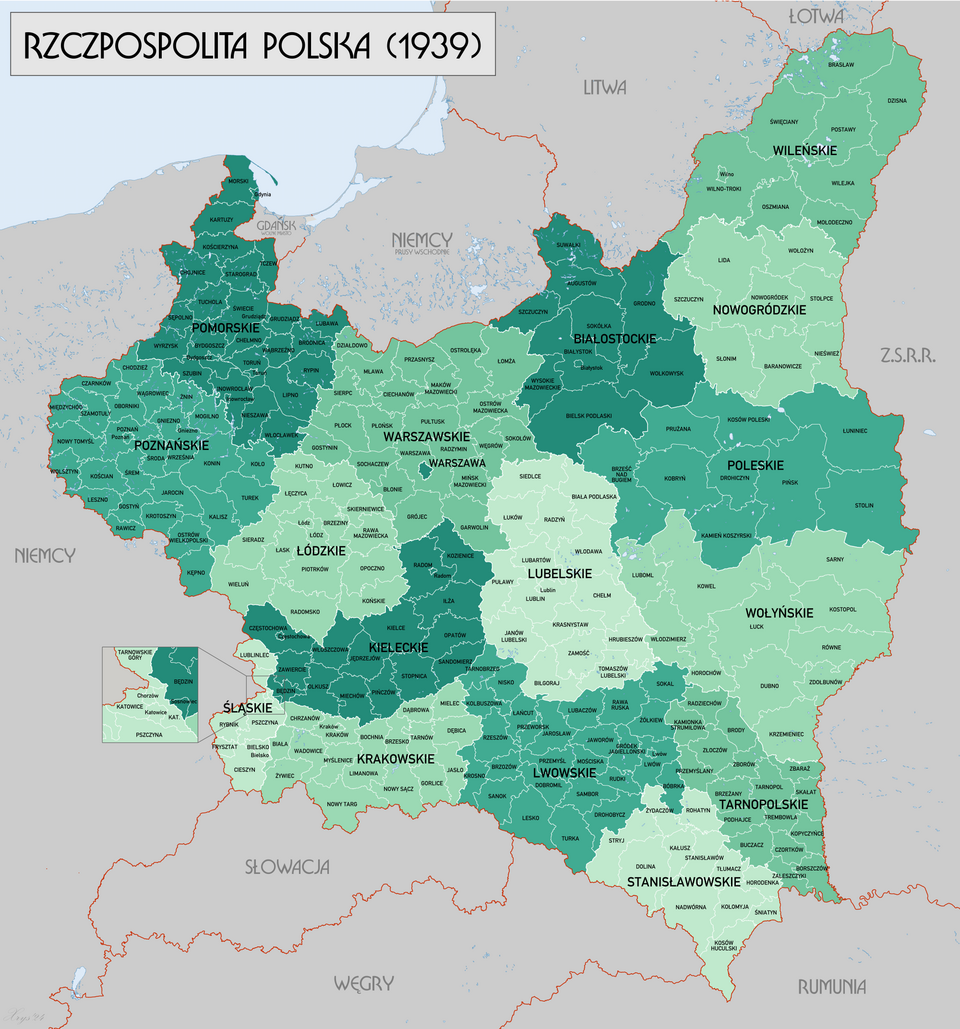
As indicated above, the administrative reforms implemented during the reign of Casimir the Great proved exceptionally durable. The fundamental territorial division into two provinces – Lesser Poland and Greater Poland – acquired a significance extending beyond the history of the medieval Kingdom of Poland and the Polish–Lithuanian Commonwealth. Notably, many of the territorial units established at that time, organised around local administrative centres, survived the period of the partitions following the collapse of Polish statehood. Subsequently, these units continued to function in the reborn Second Polish Republic after 1918. They also persisted during the period of the Polish People’s Republic until the administrative reform of 1975. Finally, they were re-established within the Third Polish Republic as a result of the comprehensive reorganisation of the state’s administrative structure carried out in 1998.
According to the definition proposed by the pioneer of research into the history of Polish administration, Zygmunt Gloger, the term powiat (county) denotes “a group of opola (i.e. neighbouring villages and agricultural settlements, surrounded and interconnected by fields – author’s note), which jointly held assemblies and courts, and were notified and convened to deal with matters of common concern.” The etymology of the term is linked to the words wiec (assembly), powiecać (to summon), and powiadamiać się (to notify one another). In their original form, counties performed administrative, judicial, and defensive functions 1 .
It is therefore appropriate to examine the process by which the original network of counties took shape. The analysis begins with the two principal provinces of the Kingdom – Greater Poland and Lesser Poland – and then turns to those territories that were later incorporated into the Kingdom and subsequently into the Polish–Lithuanian Commonwealth, namely Masovia and Royal Prussia 2 , as well as to the Grand Duchy of Lithuania in its territorial configuration following the Union of Lublin. As an illustrative point of departure, the territorial configuration of the Polish–Lithuanian Commonwealth in 1619 has been adopted. This date marks the recovery of the Smolensk lands following the Truce of Deulino with the Tsardom of Russia 3 . At that time, the Commonwealth also encompassed Livonia and the territory of Courland 4 .
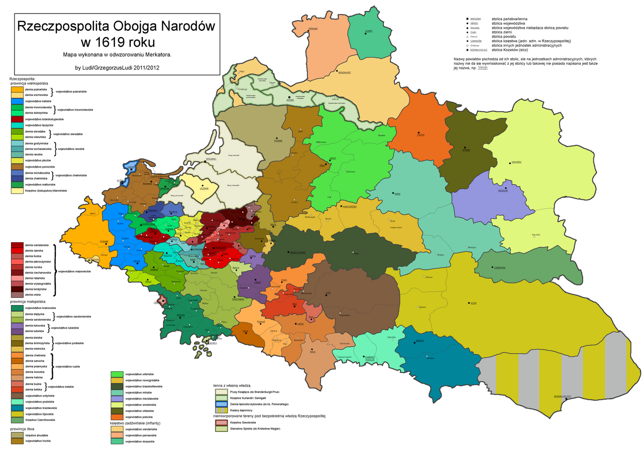
Figure 1. The Polish–Lithuanian Commonwealth in the early seventeenth century, showing the contemporary administrative division into voivodeships, lands, and counties. Source: Wikimedia Commons, The Polish–Lithuanian Commonwealth in 1619, https://pl.wikipedia.org/wiki/Podzia%C5%82_administracyjny_I_Rzeczypospolitej [accessed on: 14.12.2025].
An additional map illustrates the division of the Polish–Lithuanian state during this period into provinces, with voivodeships and lands indicated.
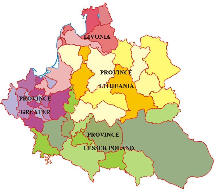
Figure 2. Division of the Polish–Lithuanian Commonwealth into provinces. Source: Wikemedia Commons, Administrative provinces of the Polish–Lithuanian Commonwealth, https://pl.wikipedia.org/wiki/Plik:Prowincje_I_RP.svg [accessed on: 14.12.2025].
Counties in Lesser Poland
In Lesser Poland, during the initial phase of the province’s existence, up to the incorporation of Red Ruthenia by Casimir the Great, three voivodeships were established: Kraków Voivodeship, Sandomierz Voivodeship, and Lublin Voivodeship.
In the Kraków Voivodeship, at the close of the fourteenth century, only three counties were in operation: Kraków, Proszowice, and Żarnowiec. During the sixteenth century, however, a series of administrative changes led to a significant reorganisation of the county network. As a result, the following counties were in existence: Proszowice, Lelów, Szczyrzyc, Książ, Sącz, Biecz, and the so-called Silesian County, which encompassed the Duchies of Zator and Oświęcim 5
. In addition, two ecclesiastical territorial units were situated within the boundaries of the voivodeship: the Muszyna Starosty (also referred to as the Muszyna State) and the Sławków Starosty. Ultimately, by the second half of the seventeenth century, a stable administrative structure had emerged, comprising the following counties: Proszowice, Lelów, Książ, Szczyrzyc, Sącz, Biecz, and Silesian County.
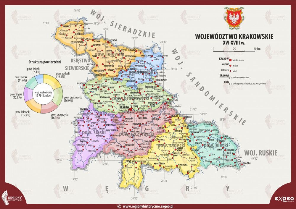
Figure 3. Kraków Voivodeship in the seventeenth century. Source: Regiony historyczne, Mapa województwa krakowskiego w XVII wieku, https://www.regionyhistoryczne.exgeo.pl/korona/wojewodztwo-krakowskie-xvi-xviii-w-mapy [accessed on: 14.12.2025].
The Sandomierz Voivodeship comprised territories divided into the following counties: Sandomierz, Wiślica, Pilzno, Radom, Opoczno, Chęciny, Szydłów (until 1465), and Tarnów (until 1465), as well as the Stężyca Land. The latter, although administratively part of the Sandomierz Voivodeship, was not subdivided into counties and functioned as a separate territorial unit.
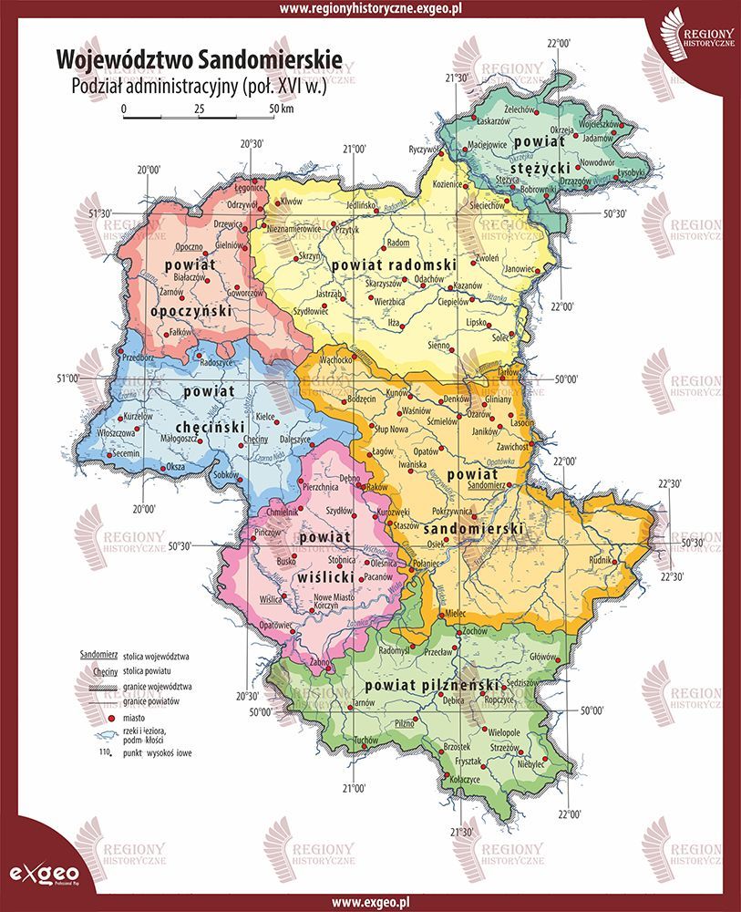
Figure 4. Sandomierz Voivodeship in the seventeenth century. Source: Regiony historyczne, Mapa województwa sandomierskiego w XVII wieku, https://www.regionyhistoryczne.exgeo. pl/korona/wojewodztwo-sandomierskie-xvi-xviii-w-mapy [accessed on: 13.12.2025].
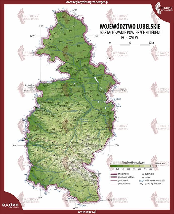
Figure 5. Lublin Voivodeship in the seventeenth century. Source: Regiony historyczne, Mapa województwa lubelskiego w XVII wieku, https://www.regionyhistoryczne.exgeo.pl/korona/woje- wodztwo-lubelskie-xvi-xviii-w-mapy [accessed on: 14.12.2025].
The Lublin Voivodeship was established in 1474, when King Casimir IV Jagiellon separated it from the Sandomierz Voivodeship 6 . It comprised the following counties: Lublin, Urzędów, Kurów (in existence until 1465), and Parczew (in existence until 1465), as well as the Łuków Land 7 .
In the mid-fourteenth century, additional voivodeships created by King Casimir the Great in Red Ruthenia – territories incorporated into the Crown – were also included within the Province of Lesser Poland 8 . As a result of their constitutional and administrative organisation, three principal units were initially formed: the Ruthenian Voivodeship, the Bełz Voivodeship, and the Chełm Land (voivodeship).
The Ruthenian Voivodeship initially consisted of four territorial units with the status of lands: Sanok, Przemyśl, Halych, and Lviv 9 . In the seventeenth century, these units formally acquired the designation of counties.
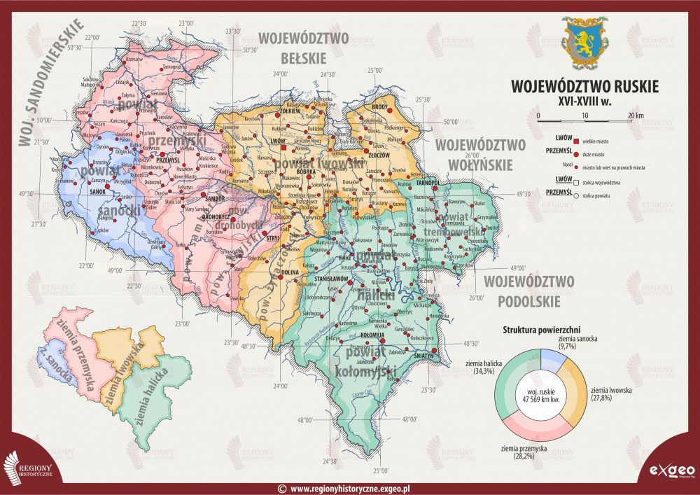
Figure 6. Ruthenian Voivodeship in the seventeenth century. Source: Wikimedia Commons, The Ruthenian Voivodeship in the seventeenth century, https://www. regionyhistoryczne.exgeo.pl/korona/ wojewodztwo-ruskie-xvi-xviii-w-mapy [accessed on: 14.12.2025].
The Bełz Voivodeship was incorporated into the Crown in 1462, having previously existed as a fief of the Masovian dukes 10 . Within its boundaries, the following counties were established: Bełz, Grabowiec, Horodło, Lubaczów, and the Busk Land.
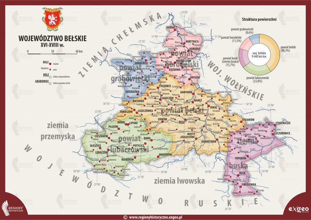
Figure 7. Bełz Voivodeship in the seventeenth century. Source: Regiony historyczne, Mapa województwa bełskiego w XVII wieku, https://www.regiony- historyczne.exgeo.pl/korona/wojewodztwo-belskie-xvi-xviii-w-mapy [accessed on: 14.12.2025].
Finally, within the Chełm Land, five counties were initially created: Chełm, Krasnystaw, Hrubieszów, Luboml, and Ratno. After 1465, only two counties remained: Chełm and Krasnystaw 11 . Over time, Chełm Land came to be referred to in official documents as a voivodeship, as it functioned as an autonomous administrative unit vis-à-vis the Ruthenian Voivodeship and possessed, inter alia, its own regional assembly (sejmik). Only in the early sixteenth century was Chełm Land definitively incorporated into the Ruthenian Voivodeship, under circumstances that remain only partially clarified 12 .
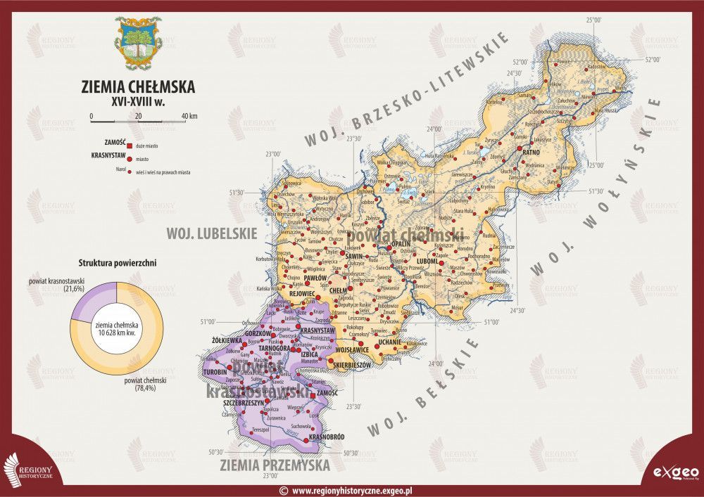
Figure 8. Chełm Voivodeship in the seventeenth century. Source: Regiony historyczne, Mapa województwa chełmskiego w XVII wieku, https://www. regionyhistoryczne.exgeo.pl/korona/ ziemia-chelmska-xvi-xviii-w-mapy [accessed on: 14.12.2025].
Following the death of Vytautas the Great in 1430, the Duchy of Podolia was incorporated into the Kingdom of Poland. After a series of conflicts with Vytautas’s successor, Švitrigaila, the region was definitively integrated into the Crown in 1437. Three years earlier, the Podolian Voivodeship had already been established 13 . This voivodeship comprised three counties: Kamieniec, Latyczów, and Czerwonogród.
As a result of the resolutions adopted at the Union of Lublin in 1569, several territories were transferred from the Grand Duchy of Lithuania to the Crown. These included the Kyiv Duchy, where the Kyiv Voivodeship was created, as well as the Volhynian Land, which was organised into the Volhynian and Bracław Voivodeships. Until the mid-seventeenth century, the Chernihiv Voivodeship also existed. At the same Lublin Sejm, Podlasie was likewise incorporated into the Crown; this region is discussed separately below 14 .
The Volhynian Voivodeship was divided into three counties: Łuck, Włodzimierz, and Krzemieniec.
The Bracław Voivodeship, established in 1566 and incorporated into the Crown three years later 15 , comprised two counties: Bracław and Winnica.
The extensive Kyiv Voivodeship was similarly divided into three counties: Kyiv, Żytomierz, and Owrucz 16 .
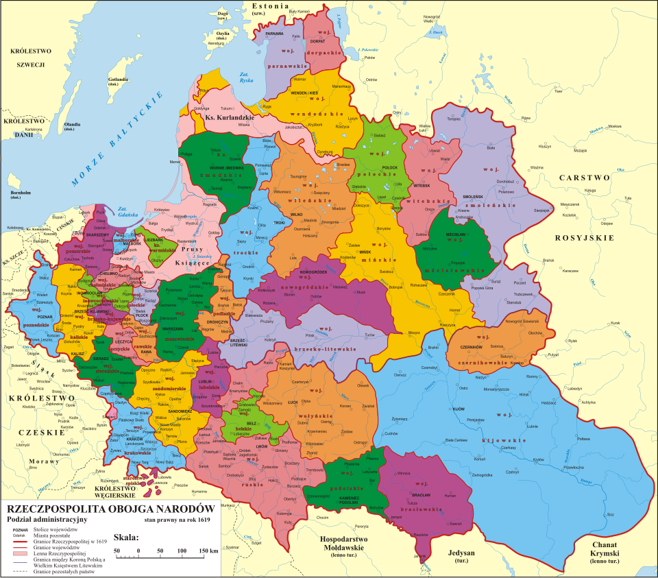
Figure 9. Division of the Polish–Lithuanian Commonwealth into voivodeships in 1619, showing the Volhynian, Podolian, Bracław, and Kyiv Voivodeships. Source: Wikimedia Commons, Polish–Lithuanian Commonwealth. Administrative division, https://pl.wikipedia.org/wiki/ Podzia%C5%82_administracyjny_I_ Rzeczypospolitej#/media/Plik: Podzia%C5%82_administracyjny_I_ RP.svg [accessed on: 14.12.2025].
Counties in Greater Poland
Greater Poland – the cradle of Polish statehood – initially comprised two historically principal lands: Poznań and Kalisz. As early as the first half of the fourteenth century, both acquired the status of voivodeships. In 1768, at the request of King Stanisław August Poniatowski, the Gniezno Voivodeship was separated from the northern part of the Kalisz Voivodeship.
Within the Poznań Voivodeship, the following counties functioned: Poznań, Kościan, Wałcz, and the Wschowa Land.
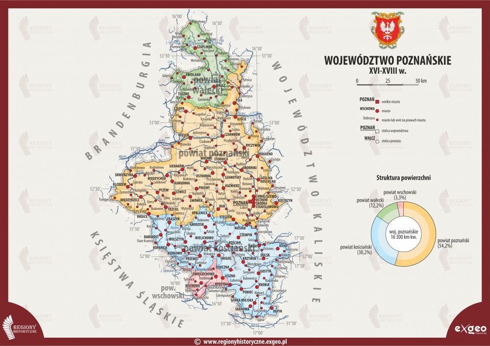
Figure 10. Poznań Voivodeship in the seventeenth century. Source: Regiony historyczne, Mapa województwa poznańskiego w XVII wieku, https://www. regionyhistoryczne.exgeo.pl/korona/ wojewodztwo-poznanskie-xvi-xviii-w--mapy [accessed on: 14.12.2025].
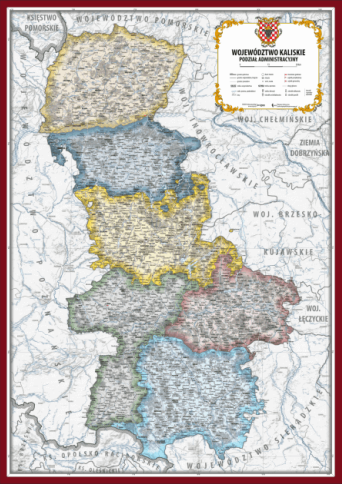
Figure 11. Kalisz Voivodeship in the seventeenth century. Source: Regiony historyczne, Mapa województwa kaliskiego w XVII wieku https://www.regionyhistoryczne.exgeo.pl/korona/wo- jewodztwo-kaliskie-xvi-xviii-w-mapy [accessed on: 14.12.2025].
For most of the period under consideration, the Kalisz Voivodeship was divided into six counties: Kalisz, Konin, Pyzdry, Gniezno, Kcynia, and Nakło. From the latter three, the Gniezno Voivodeship was subsequently formed. In the final years of the Polish–Lithuanian Commonwealth, Środa County was additionally established (from 1791) 17 .
Over time, the Greater Poland Province also came to include the voivodeships of Sieradz, Łęczyca, Brześć
Kujawski, and Inowrocław. These lands – remnants of former Piast duchies from the period of territorial fragmentation – formed a natural link between core Greater Poland and Lesser Poland. Their transformation into voivodeships took place during the reign of Casimir the Great.
Within the Łęczyca Voivodeship, the counties of Łęczyca, Orłów, Brzozów, and (from 1791) Inowłódz were established.
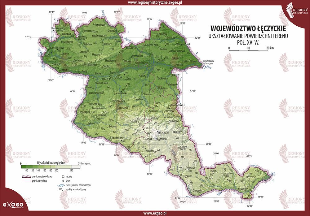
Figure 12. Łęczyca Voivodeship in the seventeenth century. Source: Regiony historyczne, Mapa województwa łęczyckiego w XVII wieku, https://www. regionyhistoryczne.exgeo.pl/korona/ wojewodztwo-leczyckie-xvi-xviii-w--mapy [accessed on: 14.12.2025].
The Sieradz Voivodeship comprised four counties: Sieradz, Szadek, Piotrków, and Radomsko. The Wieluń Land, which formed part of this voivodeship, was further divided into the Wieluń and Ostrzeszów Counties 18
Finally, the Brześć Kujawski Voivodeship was subdivided into five counties: Brześć, Kowal, Kruszwica, Przedecz, and Radziejów.
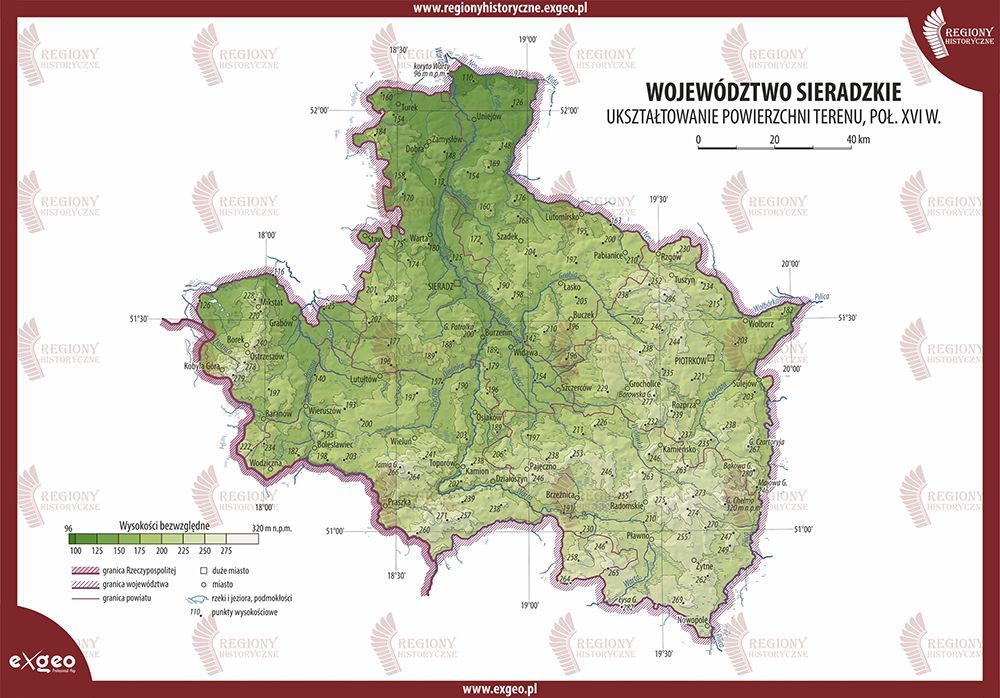
Figure 13. Sieradz Voivodeship in the seventeenth century. Source: Regiony historyczne, Mapa województwa sieradzkiego w XVII wieku, https://www. regionyhistoryczne.exgeo.pl/korona/ wojewodztwo-sieradzkie-xvi-xviii-w--mapy [accessed on: 14.12.2025].
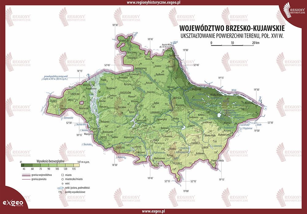
Figure 14. Brześć Kujawski Voivodeship in the seventeenth century. Source: Regiony historyczne, Mapa wojewódz- twa brzesko-kujawskiego w XVII wieku, https://www.regionyhistoryczne. exgeo.pl/korona/wojewodztwo-brze- sko-kujawskie-xvi-xviii-w-mapy [accessed on: 14.12.2025].
In the Inowrocław Voivodeship, the territorial division comprised the Bydgoszcz County and the Inowrocław County, as well as the Dobrzyń Land. The latter was subdivided into three counties: Rypin, Lipno, and Dobrzyń 19 .
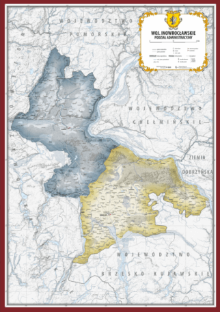
Figure 15. Inowrocław Voivodeship in the seventeenth century. Source: Regiony historyczne, Mapa województwa inowrocławskiego w XVII wieku, https://www.regionyhistoryczne.exgeo. pl/korona/wojewodztwo-inowroclawskie-xvi-xviii-w-mapy [accessed on: 14.12.2025].
Counties in Masovia
From the period of territorial fragmentation onwards, Masovia long remained outside the borders of the Crown of the Kingdom of Poland. As successive branches of the Masovian Piast dynasty became extinct, individual lands were gradually incorporated into the Polish state. The process was completed in 1526 20 . Following the administrative changes introduced by the Union of Lublin in 1569, Masovia was assigned to the Greater Poland Province. In the form shaped by earlier structural developments within the Polish–Lithuanian Commonwealth, the region comprised three voivodeships: Masovia, Płock, and Rawa, encompassing a total of thirty-three counties.
Within the Masovian Voivodeship, ten lands functioned as intermediate administrative units between the voivodeship and the county: Ciechanów, Czersk, Liw, Łomża, Nur, Różan, Warsaw, Wizna, Wyszogród, and Zakroczym.
The Ciechanów Land consisted of three counties: Ciechanów, Przasnysz, and Sąchock.
The Czersk Land likewise comprised three counties: Czersk (also known as Garwolin), Grójec, and Warka.
The Łomża Land included four counties: Łomża, Kolno, Ostrołęka, and Zambrów. The Nur Land was divided into three counties: Nur, Kamieńczyk, and Ostrów.
The Różan Land comprised two counties: Różan and Maków. The Warsaw Land included three counties: Warsaw, Błonie, and Tarczyn.
A similar number of counties existed in the Wizna Land: Wizna, Radziłów, and Wąsosz. The Zakroczym Land consisted of two counties: Zakroczym and Nowe Miasto.
Finally, the Liw Land and the Wyszogród Land were not subdivided into counties.
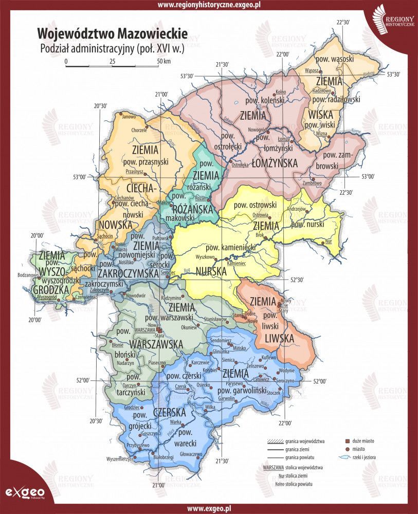
Figure 16. Masovian Voivodeship in the seventeenth century. Source: Regiony historyczne, Mapa województwa mazo- wieckiego w XVII wieku, https://www.re- gionyhistoryczne.exgeo.pl/korona/woje- wodztwo-mazowieckie-xvi-xviii-w-mapy [accessed on: 12.2025].
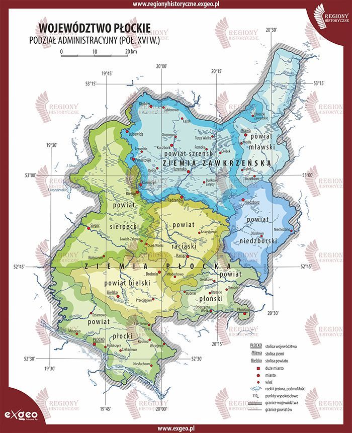
Figure 17. Płock Voivodeship in the seventeenth century. Source: Regiony historyczne, Mapa województwa płockiego w XVII wieku, https://www.regionyhistoryczne. exgeo.pl/korona/wojewodztwo--plockie-xvi-xviii-w-mapy [accessed on: 14.12.2025].
Within the Płock Voivodeship, the following counties were established: Płock, Bielsk, Raciąż, Sierpc, Płońsk, Szreńsk, Niedzborz, and Mława.
It should be noted that the counties of Szreńsk, Niedzbórz, and Mława together formed the so-called Zawkrze Land.
The Rawa Voivodeship exhibited a more complex territorial structure. It was divided into three lands, each further subdivided into two counties.
The Rawa Land comprised the Rawa and Biała counties. The Gostynin Land consisted of the Gostynin and Gąbin counties. The Sochaczew Land was divided into the Sochaczew and Mszczonów counties.
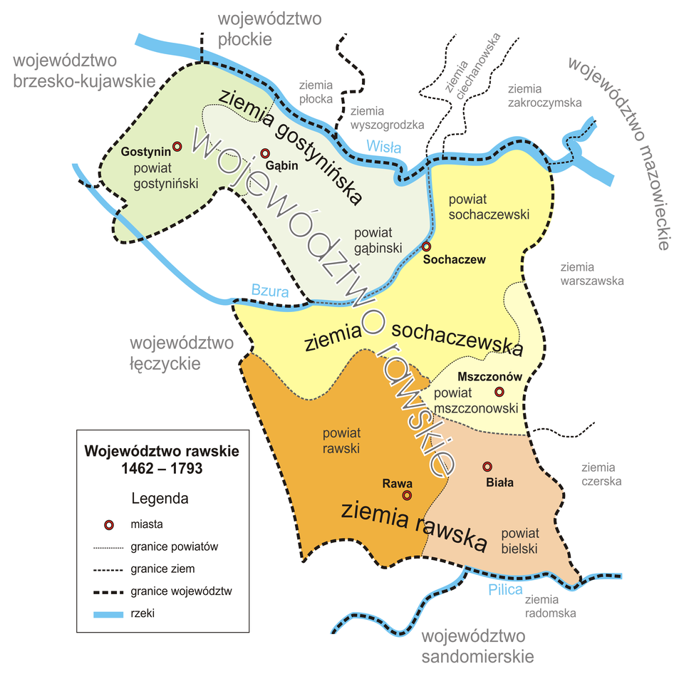
Figure 18. Rawa Voivodeship in the seventeenth century. Source: Wikimedia Commons, The Rawa Voivodeship, https://pl.wikipedia.org/wiki/ Ziemia_rawska [accessed on: 14.12.2025].
Counties in Royal Prussia
Like Masovia, Royal Prussia was incorporated into the Greater Poland Province under the provisions of the Union of Lublin. It was divided into three voivodeships: Pomeranian, Chełmno, and Malbork 21 . In addition, Warmia constituted a separate ecclesiastical territory, known as the Dominium of Warmia, administered by Catholic bishops 22 .
The Pomeranian Voivodeship comprised the following counties: Tczew, Człuchów, Tuchola, Świecie, Mirachowo, Puck, Nowe, and Gdańsk. In addition, certain territories, particularly in the Vistula delta, were administered directly by the city of Gdańsk 23 .
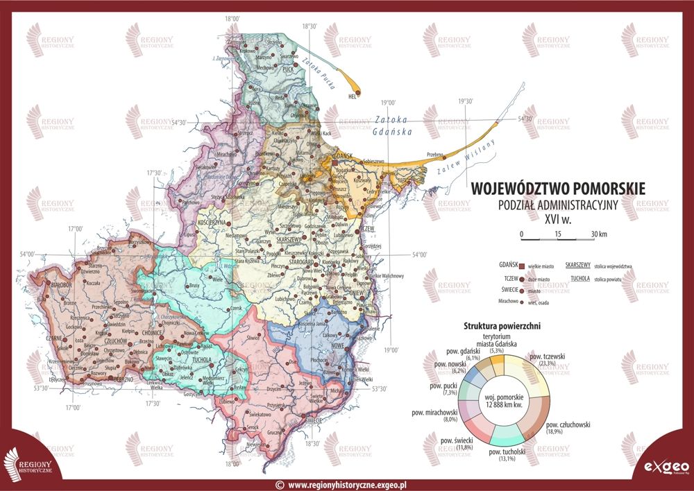
Figure 19. Pomeranian Voivodeship in the seventeenth century. Source: Regiony historyczne, Mapa województwa pomorskiego w XVII wieku, https://www. regionyhistoryczne.exgeo.pl/korona/ wojewodztwo-pomorskie-xvi-xviii--w-mapy [accessed on: 14.12.2025].
The Chełmno Voivodeship comprised only two counties—Chełmno and Michałowo—as well as territories administered directly by the city of Toruń 24 .
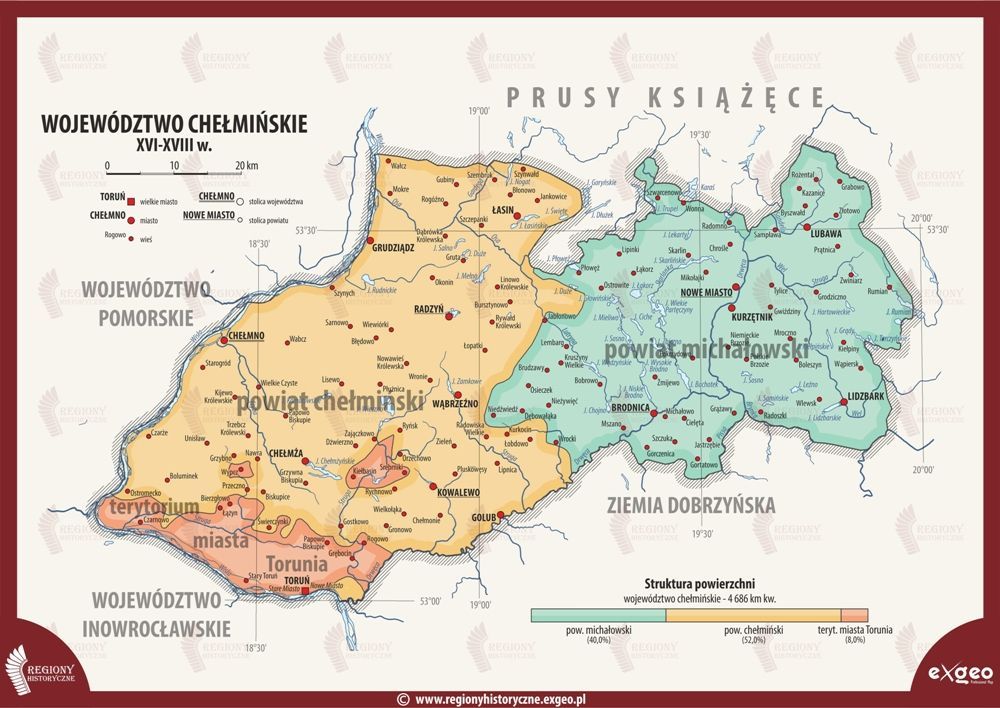
Figure 20. Pomeranian Voivodeship in the seventeenth century. Source: Regiony historyczne, Mapa województwa pomorskiego w XVII wieku, https://www. regionyhistoryczne.exgeo.pl/korona/ wojewodztwo-chelminskie-xvi-xviii--w-mapy [accessed on: 14.12.2025].
Finally, the Malbork Voivodeship likewise consisted of two counties: Malbork and Sztum.
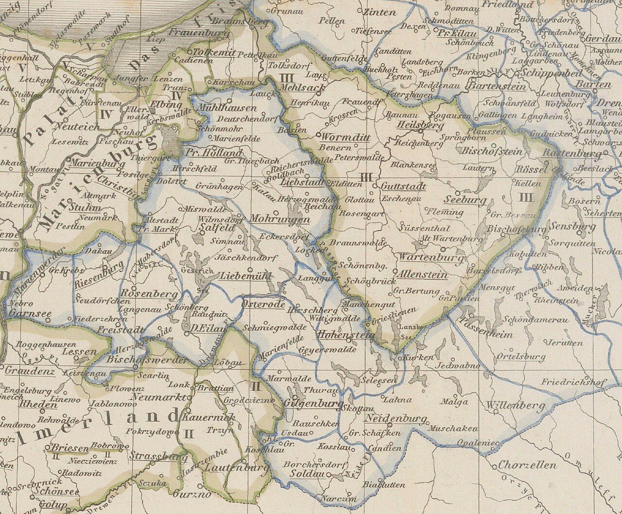
Figure 21. Malbork Voivodeship and the Duchy of Warmia in the seventeenth century. Source: Wikimedia Commons, The Malbork Voivodeship and the Prince-Bishopric of Warmia in the seventeenth century, https://pl.wikipedia.org/ wiki/Wojew%C3%B3dztwo_malborskie [accessed on: 14.12.2025].
By contrast, the Dominium of Warmia, also known as the Duchy of Warmia, did not possess an internal county structure (the territory of the Duchy is visible on the map above).
Counties in the Grand Duchy of Lithuania
Over successive periods, a varying number of voivodeships formed part of the Grand Duchy of Lithuania. Throughout the entire existence of the Polish–Lithuanian Commonwealth, these included the voivodeships of Vilnius, Trakai, Nowogródek, Brześć Litewski, Podlasie, Samogitia, Minsk, Mstislav, Vitebsk, and Polotsk. Until 1569, the Duchy also comprised the Volhynian, Kyiv, and Bracław Voivodeships, while the Chernihiv and Smolensk Voivodeships formed part of its territory for limited periods.
The voivodeships permanently incorporated into the Commonwealth contained the following counties and lands:
- Vilnius Voivodeship: Vilnius, Ashmyany, Lida, and Braslaw;
- Trakai Voivodeship: Trakai, Kaunas, Upytė, and Ukmergė;
- Novogrudok Voivodeship: Novogrudok, Slonim, and Volkovysk;
- Brest Voivodeship: Brest, Kobryn, and Pinsk;
- Podlasie Voivodeship: Drohiczyn, Mielnik, and Bielsk;
- Samogitian Voivodeship: the lands of Raseiniai, Šiauliai, and Telšiai;
- Minsk Voivodeship: Minsk, Rechitsa, and Mozyr;
- Mstislav Voivodeship: Mstislav and Krychev;
- Vitebsk Voivodeship: Vitebsk and Orsha;
- Polotsk Voivodeship: Polotsk and Dzisna 25 .
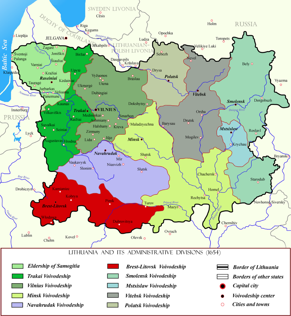
Figure 22. The Grand Duchy of Lithuania in the mid-seventeenth century, showing the voivodeships then forming part of the province. Source: Wikimedia Commons, The Grand Duchy of Lithuania in the midseventeenth century, https://pl.wikipedia.org/wiki/Wojew%C3%B3dztwo_brzeskolitewskie#/media/Plik:Brest-Litovsk_Voivodeship_within_Lithuania_in_the_17th_century.png [accessedon: 14.12.2025].
Overall, between the fifteenth and eighteenth centuries, more than 150 counties and lands functioned within the voivodeships permanently forming part of the Commonwealth. These units differed markedly in terms of territorial size, population, and internal administrative organisation.
1 Z. Gloger, Geografia historyczna ziem dawnej Polski, Kraków 1903, p. 131–132.
2 As a consequence of the resolutions of the Lublin Sejm of 1569, both regions were customarily classified as part of the Greater Poland Province. Cf.: Z. Gloger, op. cit., p. 81–82.
3 For a detailed discussion, see: A. Małow, Dokumenty polsko-rosyjskiego rozejmu zawartego 11 (1) XII 1618 r. we wsi Dywilino, “Wschodni Rocznik Humanistyczny” 2020, vol. XVII, no. 2, p. 7–100.
4 Both territories were incorporated into the Commonwealth following the secularisation of the Order of the Sword Brothers in 1561. Livonia (excluding its northern part – Estonia) became joint property of Poland and Lithuania under the Treaty of Stettin of 1570, which ended the First Northern War. The southern part of the former monastic state became a fief of the Commonwealth known as the Duchy of Courland and Semigallia. The region’s administrative system was established by the constitution “Ordynacya Ziemie Inflantckiey” at the Sejm of 1598 (Volumina Legum, vol. 2 [1550–1609], ed. J. Ohryzko, St Petersburg 1859, pp. 377–378), later amended by the constitution “Ordynacya Xięstwa Inflantskiego” of 1677, following the loss of much of the territory after 1620 and the creation of a single Livonian voivodeship from its south-eastern part (so-called Polish Livonia; Volumina Legum, vol. 5 [1669–1696], ed.
J. Ohryzko, St Petersburg 1860, p. 237).
5 For an analysis of the formation of the political system of this region, see: A. Nowakowski, Dzieje ustroju i prawa księstw Oświęciomskiego i Zatorskiego,
Białystok 1988.
6 Cf. K. Myśliński, Geneza i znaczenie powołania woj. lubelskiego w 1474 r., “Rocznik Lubelski” 1973, vol. 16, p. 9-25.
7 A broader analysis of these divisions and their evolution is provided in: K. Chłapowski, Granice i podziały administracyjne Królestwa Polskiego i Rzeczypospolitej Obojga Narodów w XV–XVIII wieku. “Studia Geohistorica” 2019, no. 7, p. 165–189 and Z. Gloger, op. cit., p. 172–200.
8 J. Szyszka, Kształtowanie się podziałów terytorialnych Rusi Czerwonej na przykładzie ziemi lwowskiej, “Średniowiecze Polskie i Powszechne” 2011, no. 3 (7), p. 120–140.
9 Z. Gloger, op. cit., p. 211–220.
10 For a broader discussion of the origins and organisation of the Bełz Voivodeship, see: A. Janeczek, Osadnictwo pogranicza polsko-ruskiego. Województwo bełskie od schyłku XIV do początku XVII w., Warsaw 1993, p. 21–34.
11 Z. Gloger, op. cit., p. 220–223.
12 W. Ćwik, J. Reder, Rozwój administracyjno-terytorialny ziemi chełmskiej, [in:] J. Willaume (ed.), Ziemia chełmska. Materiały z sesji naukowej historyków odbytej w Chełmie 21 VI 1959 r., Lublin 1961.
13 A broader treatment is provided in the monumental classic study by: O. Halecki, Dzieje Unii Jagiellońskiej, vol. 1: W wiekach średniach, Kraków
14 O ziemi podlaskiey. Przywiley przywrócenia ziemie podlaskiey do Korony Polskiey, VL 2, p. 77–80.
15 As stated in the act of incorporation of the Volhynian Land into the Crown. VL 2, p. 81.
16 For a more detailed discussion of the administrative divisions of the Ukrainian voivodeships, see: W. Bobiński, Województwo kijowskie w czasach Zygmunta III Wazy: studium osadnictwa i stosunków własności ziemskiej, Warsaw 2000.
17 Z. Gloger, op. cit., s. 80 ff.
18 H. Rutkowski, Podziały administracyjne. Granice państwowych jednostek terytorialnych, in: H. Rutkowski (ed.), Atlas historyczny Polski. Województwo sieradzkie i województwo łęczyckie w drugiej połowie XVI wieku. Część II. Komentarz. Indeksy, Warsaw 1998, p. 26.
19 For a broader discussion of these issues, see: A. Gąsiorowski, Powiat w Wielkopolsce XIV–XVI wieku: z zagadnień zarządu terytorialnego i podziałów Polski późnośredniowiecznej, Poznań 1965.
20 For a broader discussion of the administrative division of Masovia prior to its incorporation into the Crown, see: B. Sobol, Sejm i sejmiki ziemskie na Mazowszu książęcym, Warsaw 1968.
21 Numerous valuable observations on the territorial structure of Royal Prussia are provided in: S. Gierszewski, Badania nad zaludnieniem Prus Królewskich,
“Roczniki Humanistyczne”, 1987 no. 35 (2), p. 289–300.
22 For a more detailed discussion of the administration of Warmia in the pre-partition period, see: A. Kopiczko, Ustrój i organizacja diecezji warmińskiej w latach 1525–1772, Olsztyn 1993.
23 See E. Cieślak (ed.), Historia Gdańska, vol. 2 and 3/1, Gdańsk 1982–1993. This work also contains an extensive bibliography on the subject.
24 Cf. M. Superczyński, Administracja i sądownictwo dawnego Torunia w świetle źródeł z XIV–XVIII wieku, “Rocznik Toruński” 2015, vol. 42.
25 The functioning of counties in the Grand Duchy of Lithuania is discussed in greater detail in the multi-volume work edited by A. Rachuba,
Urzędnicy Wielkiego Księstwa Litewskiego: Spisy.
Udostępnij